Hi Frank
Thank you for your statement.
Is it theoretically also possible to build such areas as Zhangjiajie (When not in MSFS, in X-Plane)? https://images.app.goo.gl/sUSeRmyckz8kTUSf7
I asked me more as one time if elevation data is available with high enough resolution.
For example, how did you do your Dolomites scenery for X-Plane 11? Is it all handcrafted or did you convert accurate enough mesh data?
For Zhangjiajie I can’t imagine that there exist mesh data that is accurately enough to create pillars of rock with vegetation on the top?
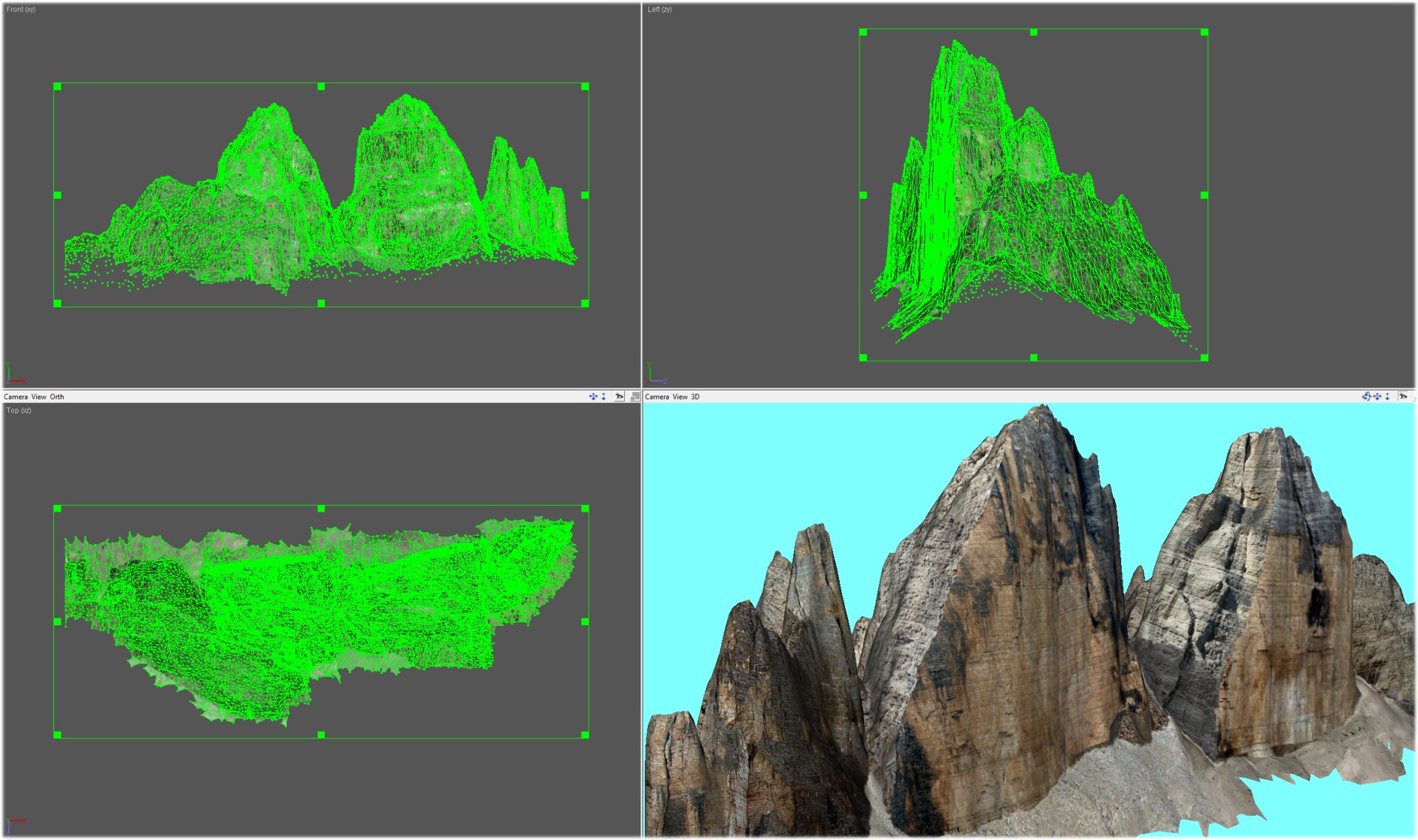
My 3D models of the mountains derive from DEMs at 5 meters. which I then reworked and improved with specific programs (Leveller and others).
Having obtained the model, I applied the textures recovered from HD photos of the same mountains, most of them shot by me in high resolution. In order to insert them in the Simulator, the base meshes must be modified to avoid non-aesthetic overlaps. All these stages of processing are many hours for each model.
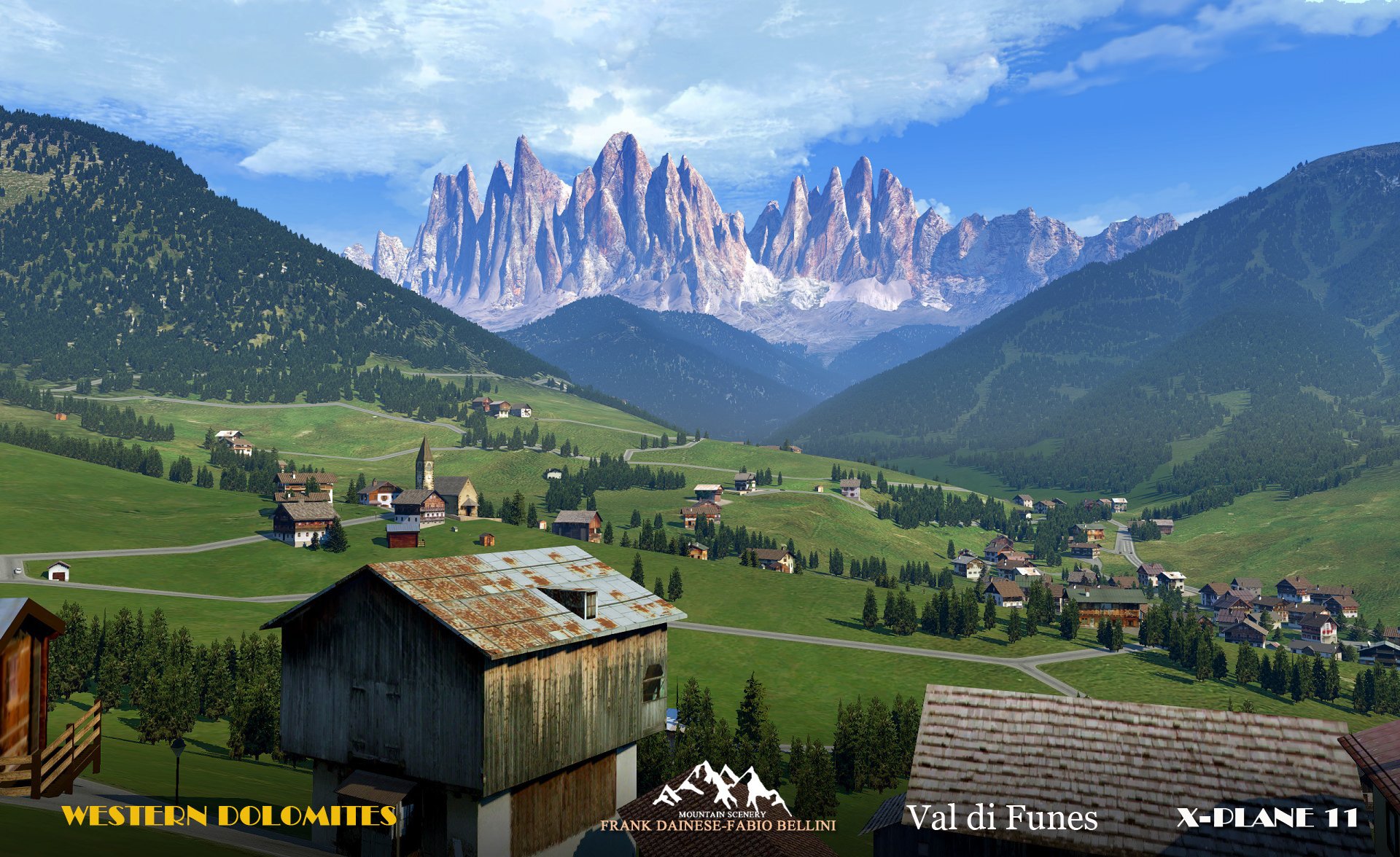
In my scenarios I also add all the 3D objects typical of that area, such as churches, particular buildings, chalets … to make the scenario as realistic as possible.
In MSFS, for now, I have not yet understood if this will be possible, the current SDKs are very incomplete and to insert a single 3D object you have to follow a rigid and not always intuitive procedure.
I attach an elaboration of “Drei Zinnen lavaredo” and a screenshots my landscape of "Val di Funes "(XP11)
9 Likes
Thank you for your fast response. It is very interesting for me to hear how you do this things.
If Microsoft and Asobo are improving their SDK and you can and are willing to do the same in MSFS, I would also buy the Everest area or even the K2 and the Matterhorn.
I think at first Asobo and MS have to fix the most important bugs, then at a second step they could update the most popular areas with a better mesh.
Simultaneously they should improve their SDK to enable 3rd party developers the development of complete sceneries inclusive accurate elevation models.
1 Like
I agree. Most important is to allow developers to work more directly and easily. To insert only one 3D object (currently) it takes many steps and strict procedure. A direct “visual” system is required as in other simulators.
Normally in my scenery there are from 20.000 to 30.000 3D objects, currently unthinkable to insert in MSFS.
I don’t think MS and Asobo will improve the simulator anytime soon (maybe ever), their goal has already been achieved, to sell very quickly.
2 Likes
I don’t hope so, there should be also motivation for them to sell more content for themselves as well (DLC’s). And if they now are lazy or thoughtless they could may lose many costumers and could sell a lot less copies.
1 Like
I’m worried developers won’t get that level of freedom though, I’ve heard that the SDK and T&C’s of use are quite restrictive as they want to make sure it’s fully compatible with the Xbox. Which is ultimately Microsoft’s end goal.
1 Like
Then it will be just a video game … Those who really want to fly will return to Xplane / FSX / P3D.
We small developers have never been helped, we have always manage for everything, we will try to do it also for MSFS … but it will be very hard.
2 Likes
I hope you can do something because we need guys like you developing for MSFS, I love your Alps stuff in X-Plane. 
2 Likes
I wouldn’t be surprised if there was a tier based monthly fee for scenery enhancements/improvements, airports, 3D objects, etc.
I thought it was mentioned last year, they might do a monthly fee for scenery? Maybe it was a rumor or the xbox pass.
We can´t ask to MSFS 2020 to give for free all the add ons that we use to have on P3D or Xplane. Microsoft give us the base for a great new Sim, and we hope that on the next months, third party, develop mesh for the sim. I used P3D with Pilot´s FS Global mesh, and that was nice. How hard can it be for Pilot´s to convert that mesh to MSFS?.
not very hard, but we need sdk tool 
As the mesh is from bing maps and bing maps is a completely different team they can get to work simultaneously. Use the synergies you created with that whole FS2020/Bing Maps liaison Microsoft!
1 Like
On the topic of bing maps:
Unfortunately FS2020 seems to really showcase how far behind bing are with their 3d maps. So far microsoft has been hiding it by making you install an app instead of embedding it in the browser. I went through the trouble to see it with my own eyes. The Matterhorn for instance has a massive crater for a peak and the drei Zinnen looks exactly like in the screenshots above: only shadows.
I could imagine that FS2020 is a strategic project to funnel some attention and funding towards bing maps. In this case we can/must hope this has positive effects for FS as well.
1 Like
BingMaps was always a terrible and unsuccessful project. And I could not care less. They could simply use better terrain data from all sorts of other scources… IF they actually want.
What annoys me is how they even brag about how great Bing is lol Partnership Series: Bing Maps - YouTube
In this video they cleary say: “blending of open scource, commercial and Microsoft datasets” for the terrain.
Well… so well then I hope they actually live up to that standard and simply use the fantastic 3D terrain from Swisstopo for Switzerland.
Problem solved. At least for some parts of the alps.
I’m sure most countries have much better data sets for their terrain too.
1 Like
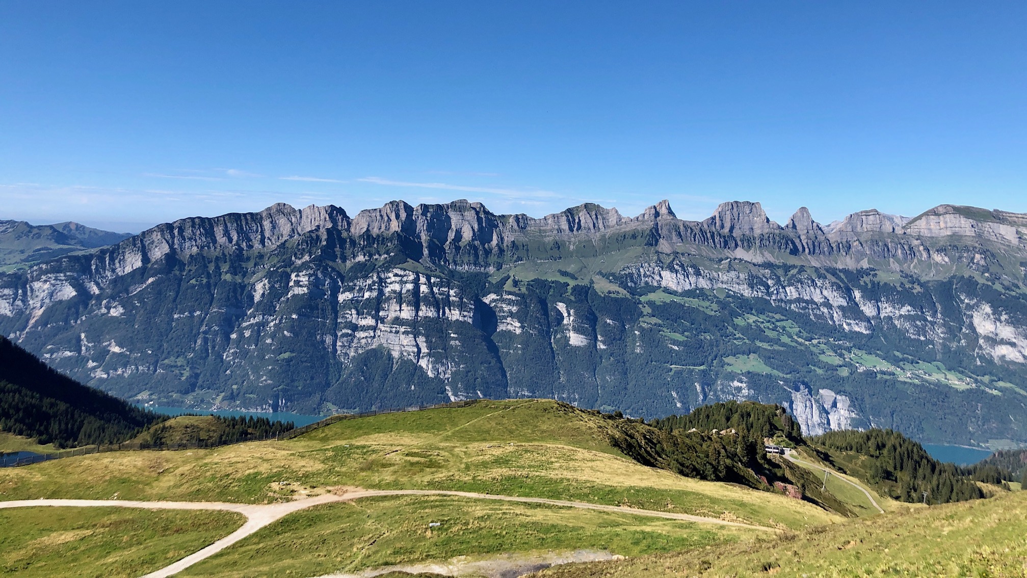
Just some more salt into the wounds:
Churfirsten, Switzerland
Reality
vs FS2020
12 Likes
For those worrying about performance of finer meshes: Have you ever switched to the wireframe-view in developer mode? The waste of geometry blows your mind. I hope all this smooth subdivision is done client side. Well otherwise there wouldn’t be any performance difference with finer meshes…
2 Likes
Wow. That is astonishingly bad.
I’ve observed similar problems in North america. Areas of of the Canadian Rockies, including UNESCO sites like Banff, particularly places like mount Rundle, lake louise, and so on, look absolutely Terrible.
Can we update this topic title to be “Disappointing mountain terrain”?
Then we can consolidate our observations and have one thread everyone can vote on so we can get it put as a higher priority.
4 Likes
Hope this time is different and it looks it can be. The more people are brought to FS2020 the better and it would be a multiplicative effect. Currently, mountains (Dolomites and I suspect also other mountain ranges) are not at all realistic. If they can improve to a reasonable level of depiction that it is already quite satisfying, people will start to enjoy more and fly more in those area. I can already see for myself, at this level, I prefer not to fly there in FS220 (in X Plane I have a HL mesh which is already quite satisfying but not highest, that could be the FS2020 baseline or even better). But if they fix it, I’ll start and the next step would be to look for even further improved scenery for those areas I prefer more. And then there is room for developers to develop state of art ultra mesh sceneries… (provided your PC can handle it! 
Voted up, Please also consider up-voting for better terrain for the British Channel Islands. All of these stunning islands are missing their amazing cliffs, valleys and slopes. We are often overlooked, as we are very small, but we are an awesome place to fly. 49.494362, -2.298107