@Pilot1811 Yes it is. It was not meant for comparison purposes, only as inspiration.
I agree! My flying is in the Rockies. Resolution is OK but I had gotten the 3 meter resolution scenery for FSX.
Reported to Zendesk.
Same issues in New Zealand and their Southern Alps ![]()
Threshold published an interesting interview with Jörg Neumann and Sébastien Wloch today in which they briefly talk about world updates and DEM. They say they‘re currently trying to obtain better data from governments and that some places will see massive improvements (see link below, starting at 1:04:14)

9 Likes
I don’t understand the part about obtaining higher res data.
Apparently much higher LOD meshes for e.g. the Alps are available since many years and usable in FSX.
1 Like
Sometimes it seems like the image resolution and the mesh accuracy are adequate, but the UV mapping is wrong, especially on steep vertical faces.
Yes, but apparently MSFS couldn’t obtain these that easily or didn‘t want to. So far, they seem to rely exclusively on Bing Maps‘ DEM. I was always a bit frightened that we wouldn’t see much improvement here because Bing Maps doesn’t seem to be too interested in a better DEM. Now it seems that the devs are willing to get better mesh data, either in cooperation with Bing Maps or by themselves, and that‘s good news.
1 Like
What they say in that video/podcast around 1:04:14 sounds good indeed. Glad they seem to have realized that the ■■■■■■ Bing data is not enough for terrain and that the need proper terrain data from the governments, etc.
In Switzerland they could (and hopefully will) get excellent terrain data from Swisstopo. They have the whole alps (at least the Swiss part) in super high resolution.
And that goes for many other countries I guess.
So let’s hope they will get that data and do something with it.
So far we have not seen any of these world updates… so it’s impossible to say how much of an improvement it will be in the end.
3 Likes
That’s why I’ll just fly over Salt Lakes for the time being, quite realistic ![]()
2 Likes
Not to me. If you have seen a true 4meter and below mesh, then the pictures above are just another example of mesh being of mediocre resolution. Yes it can get much, much worse, but this seems to be a 19meter mesh at best.
1 Like
Yes I know high resolution meshes can look amazing. But at the moment, I think there are other mesh issues which should be a lot more pressing than improving the not-so-high resolution Alps.
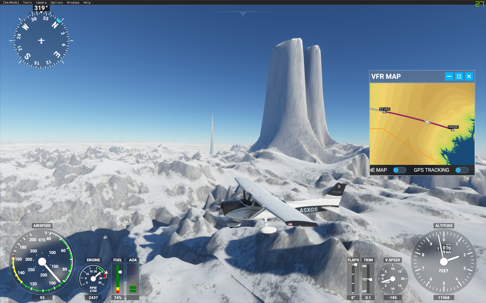
A couple of days ago I crossed Greenland in a C172, the pillars of snow just look weird, I was lucky to fly in VFR conditions, but in the end I crashed anyway because the mesh of a lake suddenly jumped up by about 1500 ft and I was trapped in its surface. I can understand to an extent that the mesh can’t be perfect everywhere on our big planet, but please at least make sure that the different levels of detail don’t contain contradicting data…

2 Likes
italy dolomites are shame! update plz
Glad to see this post as I have the same experience. Yesterday I took off from Interlaken in the Pipistrel to fly over Kleine Scheidegg and the Eiger. Resolution of the north face was no better than it would have been in FSX and it actually took me a while to identify it was really the mountain I was looking for. I hope those with skill who have looked at Japan turn their attention to these at some point. I am also on Ultra settings (which does not seem as “ultra” as it was on day one) with default resolution/rendering etc.
1 Like
We just all need a 5 meters mesh far all the Globe in place of the 10 meters actually in place.
The weight is about 100 GO for all the world (18Go for Europe and 22Go for North America), we think that the sim will support it. FSGlobal had made that for FSX, it was nice …
1 Like
If it only were 10 meters. What I see most of the the time looks more like 74 meters.
2 Likes
Fully agree. Even a 19m mesh would increase the Alps quality by at least 90%.
1 Like
19m would not be enough. It would be “better”, but it would still be quite a joke.
We need 5m or better even better than that.
With the official Swisstopo “swissALTI3D” for example, they could get 0.5m data of Switzerland.
Now what that would do to the performance of the game is a different story ^^, but at least the data is out there… let’s hope we see some vast improvements in the upcomming months.
If I’m not mistaken, Jorg Neumann is mentioning they have now access to new mesh data at 25cm resolution (at least for some areas of the world, maybe the Japan DLC will showcase this):
5 Likes
I know… I heard him saying that too. But I’m sceptical. I believe it when I see it. He did not make ANY promises. And he ALWAYS sounds excited anyway, so I take everything he says with a grain of salt.
But I think there is hope ![]()
1 Like
Looking at the areas of the globe where the mountains are really unrealistic, it is clear it is not a mesh resolution problem. The mesh values are just wrong. The top 2000ft or so of the Jungfrau for example is flattened over a horizontal distance of several Km, and Cerro Fitzroy and Cerro Torre in Argentina, two of the world’s most pointed peaks, have 4-5000 ft planed off. Even with a 100m mesh there should be something there.