Je confirme, j’ai survolé les Ecrins avec FSX et une Scenery (gratuite) des Ecrins, c’était beaucoup plus réaliste que sur FS…
Also just sent an issue to enhance the area of Machu Picchu (as a first step):
Hello
I have a suggestion for a small and easy update for the specific area of Machu Picchu (new 7 world wonder) in Peru, in relation to the mesh. I have seen, that on old SRTM data there are blank/no data areas, just in the area of the ruins… and that is what we just get in MSFS (it seems you used this data version)
i found newer data for open access:
Coverage map viewfinderpanoramas.org
a short proof in GIS (ArcMap) importing the cell “S14W073.hgt”, (download cell “SD18”) shows, that the dem is refilled with data. Although it is a very rough data for this area (same resolution as before (Arc 3’'?) with no detailed cliffs, narrow valleys) it would be at least a first step of enhancement, so Machu Picchu would not lie anymore in a flat interpolated area, but correctly at the hill, same happens with nearby town “Aguas Calientes”. For the future maybe contact the survey of Peru: https://www.ign.gob.pe/ to get more detailed dem-data
but my suggestion for you, contact https://lima2000.com/ , they have also elevation data based on contour calculation of scale 25000, very accurate for this area
Seems like good old times.
![]()
4 Likes
Go north
Same thing with the Andes and big mountains around. Sad.
1 Like
I went looking for this a couple days ago (Pico Cão Grande)

The height data is so coarse, there wasn’t a trace of it or maybe it was filtered out as an ‘error’
The sim would look so much better with more detailed height data
6 Likes
Holy ■■■■ I wish I could vote 100 times
To me this should be the most wanted improvement.
1 Like
Yes, a better height mesh is desperately needed. This is the best angle I could get of Victoria falls today

Flowing water is not in the game yet ok, but that height data, ouch.
Also the resolution of water polygons is so low it might be better to remove it instead of covering up the aerial imagery (often in the wrong place as well) I tend to avoid rivers and lakes since they’re often an angular mess. Or you get this, there be monsters in the water

Also I have no clue why water ways come with height data that overrides the terrain height, creating aquaducts. Northern Canada and Alaska are full of them.
1 Like
Victoria Falls have completely been erased, compare with Bing Maps:
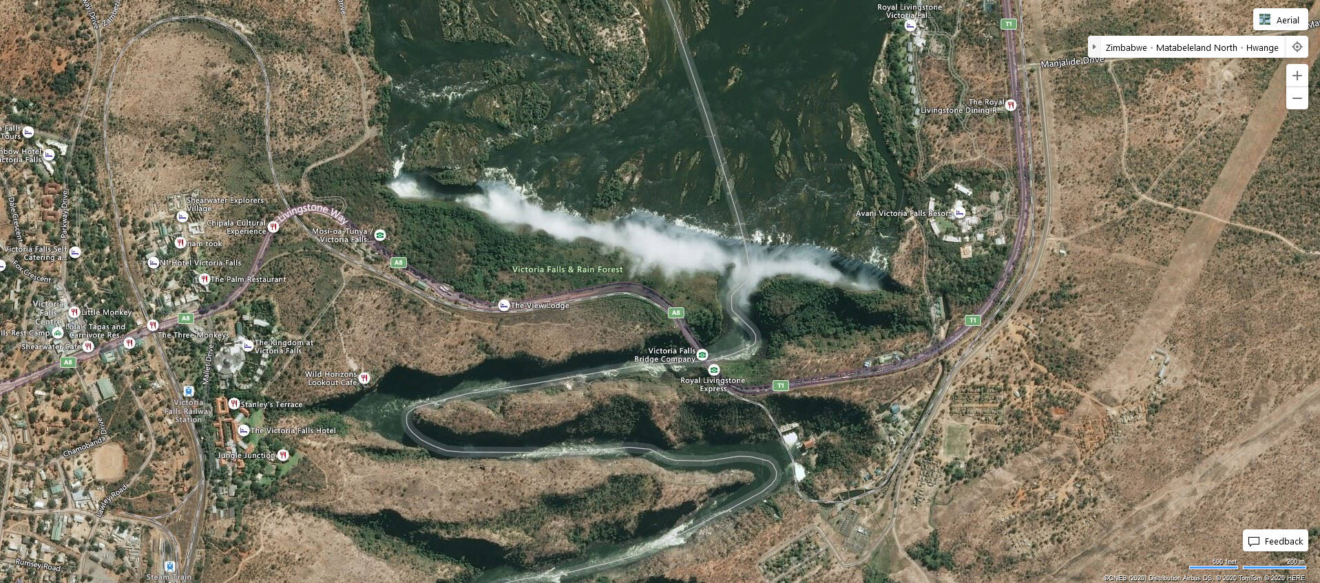
There’s also a weird carving out and filling in of the gorge as you fly over it.
I really hope they do Western Europe in World Update No. 3.
Yep, I suspect several things happen there
- The AI detects the spray/mist from the waterfall as a cloud, filters it out and replaces it with generic textures
- The height data is extremely low resolution, the canyon is missing, smoothed out
- The water data overrides the incorrect land elevation and creates an aqueduct effect
- The water polygon is low resolution, too large and covers up all the detail underneath
It all starts with bad source data. It’s not any better on Google either
I flown over the mount Cervino (Matterhorn) and it didn’t look anythingh like the real thing.
But i’m sure a world update for europe is coming.
1 Like
Yes, let‘s hope sooner rather than later. By the way there‘s an excellent freeware Matterhorn on flightsim.to.
1 Like
Thank you, i’ll try that
The freeware Matterhorn from Google is good, but it makes the surrounding mountains even more uglier.
1 Like
![]() yes, that‘s true.
yes, that‘s true.
Oh my god just saw this being voted to the feedback snapshot, and a 2021 release!
This made me curious as well. We know that they update the DEM in specific regions in their world updates but does that mean that they also plan to improve it outside these world updates? Maybe even globally? I hope they will talk about this in the upcoming Q&A.
I think that’s exactly how you should interpret it. To me it means they plan to update the whole planet with high quality mesh in 2021 so that’s fantastic. It also makes sense because the dem should be the easiest type of data to implement as everything else simply gets slapped onto it.