I personnaly hoped the altitude mesh to be part of the online data, but apparently it isn’t (not now at least). I don’t know if it’s possible for Asobo to inject a more accurate mesh into the downloaded content.
If it’s possible, we could expect a better worldwide mesh without any core software major update.
Himalaya is terrible (at least the places I have visited), I hope we won’t need to wait for a hypothetic Asian update to make it better.
It’s a pity that we need to choose our playground accordingly to its quality. I love flying in the Alps, but I stay in France because I know that Switzerland and Italy are much less well rendered.
i am not really shure about offline mesh data (which in fact has to be very huge local data):
if mesh is not online but offline, why do we have drops on runway based on bad mesh loading? or someone knows if maybe a basic mesh is local installed, and additional finer meshes from online?
I don’t think so. I’m pretty sure the 2021 for DEM simply means: It will get better region by region depending on new World Updates.
I don’t think it will be everything.
Even now in the USA Update, only some areas of the USA got really good DEM. In most areas, it’s still rather low res.
Actually, I see a major improvement throughout many areas of the alps. I am not certain this happened as a result of the last update since I have not flown in the region for several weeks prior to yesterday. In any case, the height, massing, and general shape of the mountains is much improved over the interval, Famous peaks such as the Eiger are now easily recognizable. I can find may way around the Dolomites! In short… this region now feels like the real thing. Not near the level of great payware scenery such as Austria Professional HD for FSX and P3D, but still a palpable improvement. You should check it out.
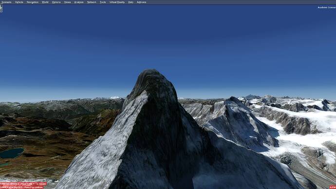
There are still many improvements required: Some major topo glitches include: Holes in the center of the Matterhorn and Grimming and a very bad elevation mismatch for the Obersee in Berchtesgaden National Park. Finally, we still have serious mismatched seasons with large patches of winter snows next to verdant summer photography. While this last issue is not a topo problem, rapidly switching from summer to winter destroys much of the improved experience from a better elevation grid.
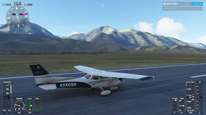
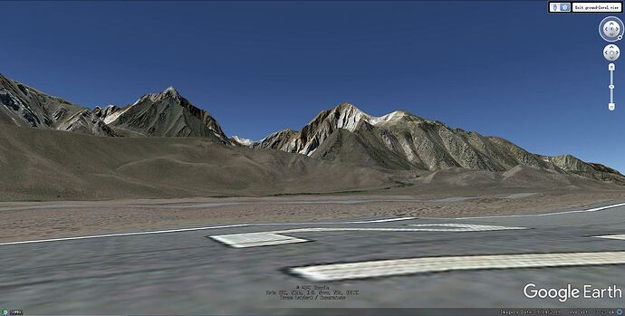
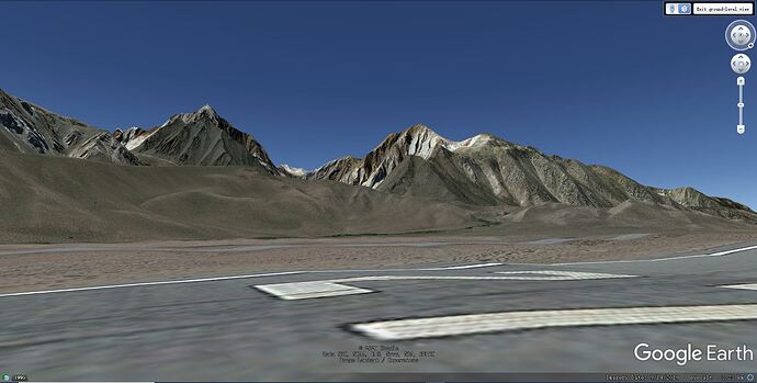
High resolution Elevation data is my most anticipated update as I really wish the smooth and rounded mountains of MSFS can get some serious facelift. After the update I took several flights to some mountain areas, and to my disappointment I can find no perceivable improvement anywhere. For verification I took a comparison picture from Google Earth. The location is Mammoth Yosemite airport runway 27 facing southwest. According to the updated elevation data map it’s 1m or 2m elevation data, but it does not look like that high resolution at all. It looks like 100m! My computer is 9900K + RTX 3090 with every graphic option set to ultra, and I cleared the rolling cache. I used to fly a lot from this airport on FSX with FS Global Ultimate terrain mesh which is 32m and it’s much better than this.
After listenning to the live Q&A, I got to know the answer. It’s not just about the data, but its implementation as well: Twitch
At 17:10 Neumann was addressing precisely to this problem of the roundness and smoothness of mountains where they should look more rugged with folds and creases. So it’s not just increasing the resolution of the elevation, but how to inject it into the terrain to make it look “vertical”. No wonder even the seemingly very high resolution updated elevation data doesn’t work so obviously. I am bit confused why this has not happened in other sims including the dated FSX. Anyway I am relieved that they are aware of this problem and I am sure they will get it ironed out.
That looks like offline terrain, seems to be a common issue.
Flying over Alps is really, really frustrating. MSFS is a simulator based mainly on the graphics and a better visual experience but if you fly over alps this it is not true any more.
In fact I will avoid the Alps until Asobo will not fix them, because they are very, very ugly.
It is appear strange to me like Asobo does not has noticed this when they modeled the terrain…it would have been enough to look the other simulators to see how they solved the elevations problem. The secret are the DEM data and how to attach to the mesh of terrain.
On FSX, Xplane, P3D exist addons that improve the elevation data. I wondering if it is not possible release soon an addon that fix the issue.
On xplane you can even do it yourself using a program like ortho4xp…
I cannot believe that is so difficult for Asobo to implement DEM elevations. I hope that Asobo look at this issue very soon because mountains are very ugly and not comparable with the other fantastic features of the simulator.
Your capture from Google Earth clearly shows that Google is doing a better job than MS in generating terrain surfaces for this particular location. I’ve found other areas around the world where MSFS results are better than Google. My gut feel is that Google and MS are probably working with the same basic techniques - the striking difference in results is likely due to Google using a denser elevation grid in this part of California. For a given grid density, you will not see details that are smaller than about 1/2 the grid interval - This is analogous to the physics of microscopes where details are limited by the wavelength of light used to illuminate the subject.
I looked at the colored maps of USA LOD levels reported with this last update. They are a bit hard to read - another resolution problem! To my old eyes, it looks like the Mammoth airport is in a LOD 14 area with an elevation grid interval of 16 meters - if that is so, elevation details such as a rock ledge or a gully narrower than 26’ are unlikely to be revealed in our flight sim at this location.
As for the Alps - well… most of them show rounded ridge lines in the Sim - I imagine the grid intervals in Switzerland, Austria and northern Italy are now, at best, no better than this part of California. Nevertheless, I still maintain that we have seen a significant relative improvement in the recent past. In my opinion, these areas have at least gone from a D- grade to a B-. In my book that’s a real improvement.
Hey,
I really hope that MS / Asobo will do proper altitude modeling for the FS2020 simulator all over the world, including the Nordic countries. The 10 meter mesh was good enough.
Attached is a picture from the Alps of my second simulator, P3D4.5, with Europe-wide accurate altitude modeling and, for the Alps, lively photoscenery.
Best regards
Esa Sairio
Finland
Initially, I placed my hopes on third party developers selling high resolution elevation meshes for folks who want to spend a lot of time flying in regions such as the Alps. Denser grids would be optional and sometimes costly add-ons similar to purchased airports. That was my experience with FSX.
I am both puzzled and worried I have seen no reports of third party efforts to create denser regional grids for MSFS. So far, Asobo seems to be the only party involved in improving the MSFS elevation grids. Perhaps it is just a matter of time : third party developers may more focused on other projects such as airports or new planes. Perhaps the needed tools have not yet been provided in the SDK.
There is another possibility: The following is pure speculation and perhaps reveals my abject ignorance of such matters: A key feature of this sim is it’s populating the surface of the world with detailed structures and vegetation: As I understand it, MS/Asobo periodically rescan the Bing surface photo images of the Earth to identify the location of objects and apply AI and regional procedural rules to infer the appropriate type of tree or style and size of building for each location.
Perhaps the elevation grid is an essential part of this process. If that was the case, it might mean that MSFS can have a wide variety of regions with different elevation grid densities, but any specific region can only have one unique elevation grid. This would imply that Asobo would have to serve as provider and gate-keeper for all large area elevation grids.
I have not followed these forums closely. Perhaps all this has been covered before - if so I would be grateful for any advice on where I can read more.
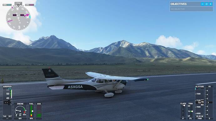
Update: I found an option in “data” - “use Bing map imagery” has been turned off, and I turned it on. Now it’s using the Bing satellite imagery as texture, and it adds much more sense of “roughness” of the mountains. So my previous comparison is not fair. Yet Google still looks much better:
Another thing that grinds my gears: Rivers or creeks in mountain valleys. Because the mesh is such low resolutions, rivers often flow uphill. Just check the Dudh Khola river below Lukla airport.
Maybe that doesn’t bother a lot of people, but it bothers me a lot. Not because I actively choose to be a whiny b*tch about it, but because it actually ruins my experiance flying around in the Himalaya
![]()
Btw the same issue exists with highways on Hong Kong Island. These have turns with steeper banking than Talladega speedway…
Agreed that Google looks better. But which one is more real? We need an actual photograph to judge that.
Could be that Google has a godo algorithm for making mountains look more dramatic than they actually are. (Although I think it is a safe bet that the Google image is the more correct one.)
It’s not just that particular mountain, but all mountains of MSFS look smooth and soft, with the exception of the very few custom 3D ones such as Mountain Fuji and Monument Mountain. This is certainly not right. It’s still open to debate whether this “softness” is caused by low resolution elevation data, or some kind of algorithm, or both.
I completely agree that mountains look underwhelming almost everywhere. Way too round and smooth. The rocky aspect is missing. Extremely noticeable in the Alps, Himalayas etc…
This would be a huge improvement for Asobo to work on that. Perhaps as an additional option as it could impact performance ? Though when I see the amount of geometry in big cities I’m not shure adding details on mountains would be so taxing for the game engine…
Mesh resolution has never affected performance. Only loading times are increased by it.
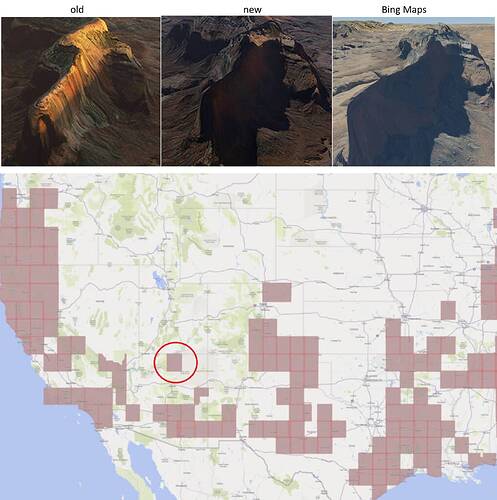
Sadly, with the latest update, Asobo has actually reduced texture detail. See this compairson near Lake Powell. First they lowered the water textures, now on to the landscape. What’s going on here? Image on the left is at Launch, image on the right is after the latest US update.
They are definitely improvements, even in areas where no official update has been delivered.
I don’t think they reduced texture detail. Judging from the shadows, I’d say that the discepancy is due to new imagery. In the image below you can crearly see that the aerial images aren’t the same. So this has to be the result of the imagery update. But I agree, the earlier one looked better.
I hope this item gets sorted out soon (as it’s under investigation)
