When i make a flightplan with the world map in the sim it don’t load properly in the vfr map or gps. anyone know whats happening please
I encountered the same yesterday when loading a flight plan. The waypoints are added, but the magenta line is not drawn. Are you experiencing the same?
1 Like
yes exactly the same as you the waypoints are there but no magenta line between them
1 Like
Yep same here.
Been like that for some time.
I think SU3 did it.
It seems it happens when I put a POI in the flight plan. If I make a simple VFR flight plan from airport direct to another airport then it’s working. I did not test with IFR.
This is due to a current limitation of 7 characters for a waypoint name, to show up the magenta line towards it in a flight plan
If you select a POI, it is likely that it will be more than 7 characters long, so the magenta line will not show up flying towards this waypoint
You can manually edit the .PLN flight plan file to crop waypoint names up to 7 characters long, so that flight plan will show correctly on VFR map and glass cockpit instruments
I opened bug #102246 for this issue
With the small number of votes it seems like an insignificant issue and unlikely to be addressed any time soon. Strange, as it impacts a number of areas that’s supports our flying. I really wonder about this voting system.
Luckily the voting system is not the only metric used in determining priority.
I must add, as a result of comments from others, I have been able to work around the issue by assigning a code, e.g., POI2 (point of interest 2) and using a descriptive name to specify the point of interest in Little NavMap. When it comes across to MSFS, you only see the codes for the waypoints but the course lines remain throughout the flight. This is a better result than my earlier experiences.
Asobo still have work to do, in that if you fly to any of the points of interest using MSFS to create the flight plan, and if the name of the point of interest is greater than 7 characters long, it will not show any routing lines in VFR Map or any of the Nav screenes in the planes, e.g., MFD Map displays.
I create route on the world map, and it shows up ok on map. however once in aircraft, and look at vfr map, the magenta route line is not reproduced. this has been happening for a long time. prior to the latest update.
Detail steps to reproduce the issue encountered:
PC specs for those who want to assist (if not entered in your profile)
Build Version # when you first started experiencing this issue:
Are you on the Steam or Microsoft Store version?
Did you submit this to Zendesk? If so, what is your ticket #?
- Do not use POI with six characters or more in your flight plan
I did not find the fix for this issue as someone was talking about another related issue importing a flight plan and I have lost the thread and am out of time today. So I will just post the fix in case people missed it and or are still running into the bug which can be frustrating. I tested it and it seems to work so for now I will say solved unless I run into it again.
Do you have any add-ons in your Community folder? If yes, please remove and retest before posting.
Navigraph Subscription
Are you using Developer Mode or made changes in it?
No
Brief description of the issue:
VFR route disappears from VFR Map and also Garmin display. Autopilot will continue to fly the route.
Provide Screenshot(s)/video(s) of the issue encountered:

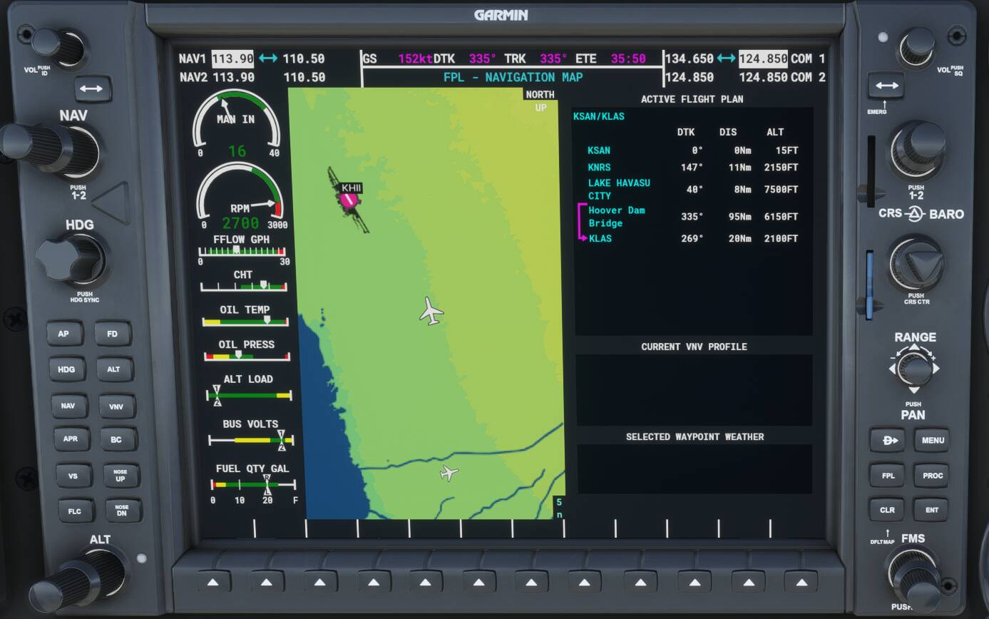
Detail steps to reproduce the issue encountered:Nothing special to do. It just does it. Was doing a flight from KSAN to KLAS with a waypoints at Lake Havasu and Hoover Dam. Notice that on second photo the distance from KNRS to Lake Havasu is only 8NM.
PC specs for those who want to assist (if not entered in your profile)
Did you submit this to Zendesk? If so, what is your ticket #?Yes, 99485
Someone posted earlier that POI names with greater than six characters as part of a flight plan will cause the Magenta Line to disappear.
5 Likes
That may explain it, third waypoint is LAKE HAVASU CITY and fourth Hoover Dam. I have update the Garmin which now shows the flight plan.
Thanks for the info!
This worked fine before sim update 3 and did not get fixed with the latest update.
3 Likes
Hi, all PLN files I downloaded from the internet show in my in game avionics. I now have created two PLN files myself and while I can load them in the sim no problem they don’t show in game, neither in avionics nor in the VFR map. I cannot see anything in the syntax of these PLN that differs from other PLN files that show up in avionics. Could anyone please help?
Thanks!
8000ers Nepal.PLN (3.7 KB) 8000ers Pakistan.PLN (2.9 KB)
EDIT: the POIs show in the avionics menu but not the plans
Do these plans include POIs (i.e. cities, named tourist spots, fauna etc) and are they six characters or greater in name length?
You can find them attached above. They include custom coordinates with custom IDs - these IDs are longer than 6 characters.
Edit: sample waypoint:
User N28° 35' 51.42",E83° 49' 14.22",+008500.00 -1Yep. That’s a recently discovered bug. Make the names less than six characters if you can. For fixed POIs in the sim, there’s no workaround. The AP will follow the route, it’s just the Magenta Line will not appear.
1 Like
Super! Thank you. All sorted now.