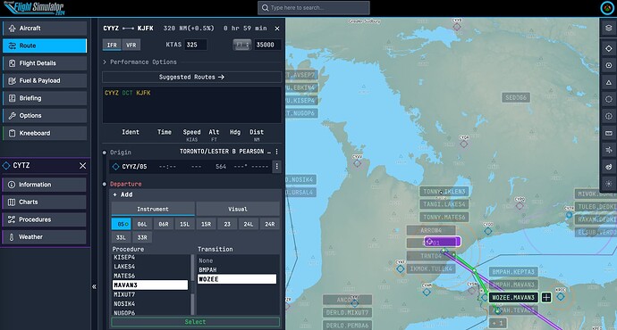
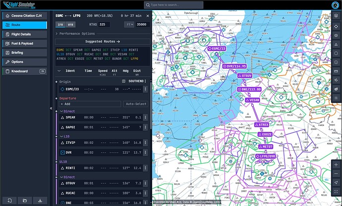
Noticing a new Flight Planning website link - I think this means you can access the new flight planning in a browser on computer or tablet outside of the sim:
This is fantastic.
great! thanx
Playing around with this while I wait for the loading queue to get into the sim.
Lots of good things - much better than what we had previously. And I’m sure it will grow over time. So here’s some timely feedback:
So far I’m left wanting with the VFR chart. It’s certainly better than the old VFR charts in the sim, but missing a lot of information that a sectional would give, namely obstructions and airport info.
Airport info can be displayed, but not at a glance - you have to go into several different tabs to find CTAF and AWOS, for example (and CTAF is in a tab called TWR, which is kind of a misnomer).
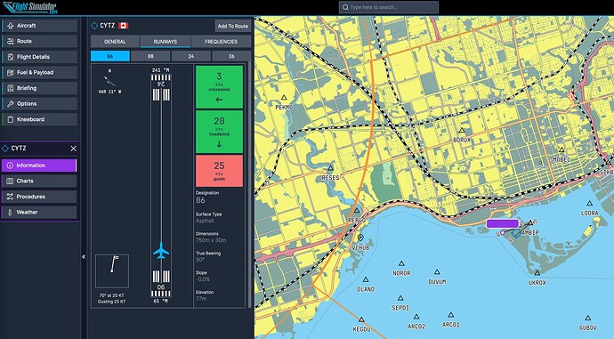
Airport elevation, runway lengths and widths are given in meters, even at US airports. Full stop, no US GA pilot is going to use meters. We’ll have to convert everything and that’s annoying (and dangerous if it were real-world ops). Please allow this to be shown in feet.
There is no information about traffic pattern direction or altitude anywhere, which is not good. Runway lighting info is also not given (unless there’s an associated approach chart, but still, this info is required for irl flying and approach charts aren’t always available).
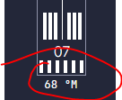
Runway azimuth is given in true heading, then there’s a variation given at the top. True heading is just about useless for runway headings except in polar areas. This should be magnetic - having to do the math every time (especially for those who don’t know whether to add or subtract east or west variation) is going to cause problems, despite the overall azimuth being given with the number.
Weather is not displaying (“current weather information is not available”). I’m guessing that’s a launch day bug.
The FAA approach charts are very welcome. This ensures coverage of the US. However, there is no airport chart provided by the FAA for many small airports, and the VFR chart doesn’t show taxiways or other important airport details, so we’re left a bit wanting on that end.
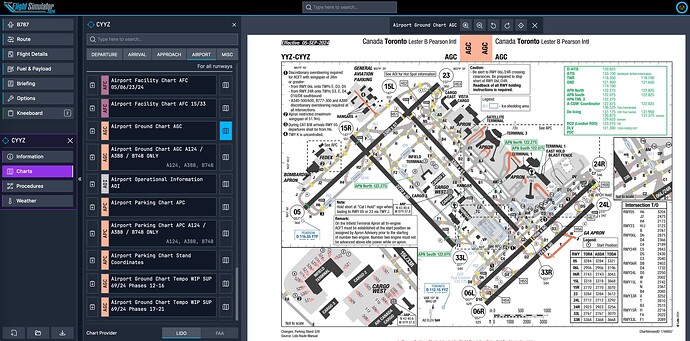
The LIDO charts are going to be fun to dive into (this is my first exposure). There are several things I like - some of the route depiction is more clear. I like how they’re zoomed in on some procedures - that detail could be important.
There are a couple things here that are what a few of us expected to be problematic.
Number one is no category A or B minimums. That’s kind of a show-stopper for GA use in some places. I guess we can use cat C, but those are often higher and farther, as you’d expect.
Two, runway lengths are again in meters on the LIDO charts. That’s fine for everywhere else that uses them, but annoying for US ops. We can always use the FAA charts, I guess.
I like the Airport Operational Information (AOI) page. Runway lights are notated there if you want them, but it’s in a different format than I’ve ever seen. Thats okay, but will take some getting used to (though the MALSR pictogram doesn’t look at all like a MALSR).
The LIDO charts are all rotated to magnetic north. That’s different. Whereas true north is meaningless for runway headings (as mentioned earlier), it works well for maps. Otherwise, everything is always needing a rhumb line (over distances north is going to shift). Not a show-stopper, but unexpected and will take getting used to.
There are several navaids I’m seeing on LIDO charts that have long since been decommissioned (we’re talking over 15 years) but still showing on some charts that indicate 2023 effective dates).
I’m not seeing park spot coordinates if you’re looking to align an INS.
Oh, interesting, as I’m wrapping this up I just got past the loading quest and at the same time, weather started appearing in the planner, so maybe it was a server thing that’s been cleared up.
Anyway, more to come as I dive further.
Sweet. This looks great, but I think I will keep my Navigraph subscription for a little bit, until we figure out if this tool/planner can replace it. Heck, maybe you already know if it is worth keeping Navigraph or not? I would venture as of now, the answer is to keep it?
Please keep the updates on this coming as I saw your thread after I was done on Flight Sim for the night and did not want to get into anything else related to it except the forum. I did sign into it, and give it the permissions needed for Xbox and all that.
Sorry if this post is a little “off” as I am exhausted but trying to go through and read posts of interest and what not, but I really need to get some shuteye and start over later today (Wednesday), haha. It was a long, frustrating day…to say the least!
Thank you for the info, and thanks in advance for anything new.
Xbox Series X
At this time Navigraph is a more mature and complete solution, especially for the US. However, this service is definitely competitive and will likely grow into a similarly-featured player.
Navigraph really not need it anymore. Thanks Working Title! ![]()
I was hoping this new planner would allow access to a realtime nav map using xbox which we were not previously able to get data from. Any idea if they will add realtime mission nav with this?
Not yet, if you fly GA and/or are US-based
GA and US is possible. Using FAA Charts also at the moment ![]()
It’s possible for IFR airports, but still a little wonky for non-IFR airports due to the reasons I stated above. And I see zero support for any private fields. Consider that many of the airports that are used for careers in the sim are private (and would not be used as such in real life, but that’s another issue). I’m sure it’s a work in progress.
It seems like a very promising tool, and having the LIDO charts for free is a huge advantage. Personally, I continue to use Simbrief because I’m used to it, but little by little, I’ll also thoroughly try out this planner.
yes it is!
Just figuring this out, I’m on Xbox but signed in to the flight planning website in a web browser on the computer.
For example Toronto CYYZ has charts and runway info including quick glance indicators for headwind and crosswind. Interesting to see the differences between Navigraph and LIDO charts.
Smaller airports such as CYTZ Toronto Billy Bishop are listed, with runway info, but not charts. Wondering if the Lufthansa LIDO charts are mostly large airports?
Selecting Departures, Arrivals and Approches is a little buggy and there is a delay as it seems to load the options and try to display them. Selecting one doesn’t always “stick”.
This is indeed the case and has been acknowledged as such by devs. Small US airports are fortunately covered by FAA charts.
I love the tool. I’m struggling to work out how to get an FPL planned in planner into MSFS 2024 (game)?
Can’t seem a way to push it there..
Can it be exported as a .pln somehow? I was expecting the saved plans in the planner would be openable in “Load from Xbox Cloud Storage” in the in game EFB, but cannot seem to do that.
It should show up under load flight in the tablet after you have saved it. Then you can submit it as atc flight plan and also send it to avionics. It works on the Xbox
can anyone on PC confirm they actually got it syncing?
for what it’s worth, if any people working on this ever read this thread, it would be great if this could have an ‘active’/‘last’ flightplan that was totally synced and that can be pulled to the in game tablet with a single button (or really, automatically had it in? it feels like the site and the tablet should be in sync to me personally), which could then be synced to avionics etc, as easy as simbrief has been for other planes but fully detached from their systems (and their subscription model)
also another side thing, for me this site runs awfully in chrome, even in an icognito window with no extensions but on firefox with all my extensions it’s very very smooth, is this just a me problem?
I can create a flight plan on the flight planner site, name and save it, then access/load it on the in game EFB and send it to avionics. Which I really like.
If there’s a way to see the live data from in game on the flight planner site, or make real time changes to the flight plan I haven’t figured it out. I was hoping to use an iPad while flying instead of the in game model. Hopefully that’s coming, or I need to find a menu option I haven’t yet.
