Thanks … another issue explained …
Thank you for this info!
That would just make too much sense.
If I was Garmin I would almost INSIST that they used the Garmin Code !!.
Putting out Sim Garmin units, that do not work as the real unit do, is NOT a good reflection on Garmin, no matter what way you look at it.
Maybe coding the interface while hiding the actual Garmin IP, is the issue ??
"Ours not to reason why, ours just to do and fly "
That’s OK, I am still confused … do not yet have it all figured out.
In my ignorance, I would have assume they there would be a way to ARM the approach, so that it went into approach mode when it hit the 1st Fix on the approach .
Trying to learn the Idiosyncrasies of each GPS, especially when the Sim Units do not always behave in the same way as described in the RL Operator’s Manuals, is what I am finding “an interesting challenge”. I though GPS navigation was meant to make things easier !!!
Gosh it’s been a while. I want to say, that in the real unit, you only have to load the approach, and not even activate it. Once you hit the last enroute waypoint you will automagically navigate along the route to the first approach fix. This way, if I recall, you don’t lose your route line for the enroute fixes behind you. You can also navigate direct to a leg, and accomplish the same thing.
Again, all from memory, so big grain of salt…LOL
I believe (at the Moment) the removal of past waypoints is a FUDGE to get around a BUG elsewhere, where the plane can start going to a previous waypoint by mistake ??
With that FUDGE in place, I have no idea what happens if your REVERSE the FP ??
DO those removed WPs come back, or are have they been permanently deleted ?
In the RL 530 and 430 we always had to activate the approach
This is a very long thread. I’ve done a cursory skim through it but wasn’t able to find out this info, so I’m asking here.
I’ve done ILS approaches with the 530 mod. I activate the approach on the GPS, then hit the APR button on my Logitech panel like I would with a G1000 or 3000. It catches the glide slope and takes me down right to the threshold without issue. I find the lack of any glide slope indicator confusing (I could just not know how it works too - the more likely explanation), but it works like it would on any other aircraft.
For the life of me though, I can’t get it to find a glide slope on any RNAV approach. I activate it on the GPS unit, the tracking mode is set to GPS as it should be, and it does my lateral navigation just fine. But it never catches a glide slope and I have to bring it down through the steps on the approach plate manually. These are pretty familiar approaches for me and I never have any issue following them with other planes. I just can’t get them to work using the 530 - default or modded.
Is this normal for the 530? I was under the impression it could do RNAV approaches including the VNAV portion of it. Am I doing something wrong or am I looking for functionality that doesn’t exist?
Interesting, so if you had to do it Manualy, you then had to do it at the correct time, or risk the plane deviating from the routes you expect ??
We didn’t activate it until ATC cleared us for the approach. In that case you have an assigned altitude and heading or direct to so you have terrain clearance. You are usually told to maintain a specified altitude until established.
Ahhh . that could well be where I am not using the GPS correctly, and I am going to blame MSFS ATC ( and take a pass)
I have never heard MSFS ATC Approach give me a correct final vector clearance to the approach … at the correct distance from the IF.
So true, it really doesn’t do IFR at all
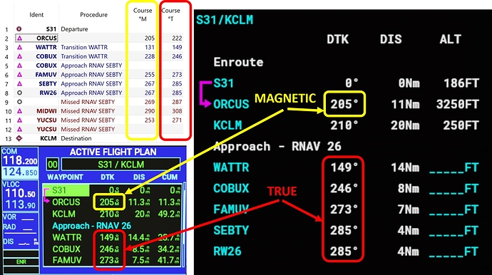
Garmin Flight Plan page shows Approach as TRUE course. If this is a BUG please somebody with good English report this bug to Zendesk. Thank you!
P.S. Flight plane images: Little Navmap 2.6.2b, GNS530 Mod 1.0.6, G1000 Default.
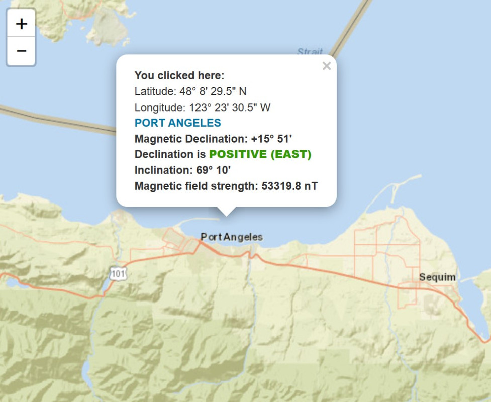
Port Angeles Magnetic Declination: +15° 51’
Yeah, a lot of CFI’s teach that. It’s not necessary though. The unit will auto-sequence to the approach even if don’t activate it, yet will still preserve your enroute waypoints. Activtating the approach, if I recall, just puts you on a “direct to” the initial approach fix.
A lot of people think this is heresy… LOL. Do a quick google search about this topic, there’s a lot out there about activating vs not activating.
Yes, obviously it is displaying True North – that is the major issue. GREAT EXAMPLE
The secondary issue, is that it seems to be using a Historic value of MagDec to calculate the magnetic bearing.
If MSFS are pulling current Approach Plates, that have the current MagDec, but MSFS is using some historic values, then even more confusion sets in, opening up the whole can of worms about updated nav databases.
I also get the impression that it a lot more complex than this, but when this stuff is wrong, and you are flying a course, that is different to your heading, one typically assumes wind, which now, may or may not be the reason for the difference,
?? What MagDec is LNM using ???
There are other areas in mSFS where Directions seem to be “Confused”.
ie setting the Wind in Custom Wind Profiles.
Wind COMMING from the North is called a North Wind.
Typically, all Aviation depictions of wind direction have an arrow that points to where the wind is coming from.
Yet, in the UI for setting up the wind, the Pointer for the wind points in the direction that the wind is going to, but is is called by the correct Direction.
ie North wind with arrow pointing to the south !!
Does not help that the NWS and it’s Metars has it’s winds reported as True Bearings !!!
Is Asobo converting this correctly when it is brought into the Aviation / ATC part of the sim ???
All this must be driving many hardened simmers crazy with frustration.
In my example LNM uses MSFS2020 Nav data and Thank you very much for your answer. Seems not too much people bothering with the MD issue. 
Depends were you fly (and how you fly !!! )
If you “fly” with AP on as soon as your wheels leave the ground, and only turn it off at destination when approaching Minimums, then yes, you might not even notice it !!!
Not sure I inddrstand you correctly
Wind depictions in aviation always show arrows (if arrows are used, normally wind barbs are used; but same concept) that point in the direction of the wind, i.e. a northerly wind comes from north and blows south, meaning the pointy end points south.
METARs and wind charts always give wind directions (BTW they are not bearings but absolute directions) relative to true north also.
However radio transmissions (i.e. tower on landing clearance) always give wind directions relative to magnetic north.
Is that what you meant is wrong in MSFS? I do think it gets it right
I guess I can see where folks might differ on it. The reason we taught it that way is because 1) When you are given your clearance by ATC you are “cleared to XYZ airport via as filed” so unless your filed flight plan includes the IAF and subsequent fixes, you are not authorized to fly them, your clearance is from the last waypoint in your flight plan to the airport direct, it doesn’t contain an approach. 2) Once ATC clears you for the approach you are now authorized to fly it, usually by being cleared Direct To the IAF or to a fix on a feeder route so your enroute waypoints are no longer relevant, if I’ve been cleared Direct To the IAF then activating the approach is the best way to accomplish that. 3) If you have not been cleared for the approach upon reaching your flight plans last waypoint, you are not cleared to the approach fix so you must then do a Direct To the airport, reload the approach, then push ATC for your clearance. They will probably recover by giving you some assigned headings for a “Vectors to Final”. I don’t like using Vectors to Final because you lose the waypoints on the approach and it can mess with your SA.
This is the reason I usually file all the way to the IAF on my flight plans. You might not be given that approach, but it sets you up well and if you lose comms, ATC has a good idea of your intentions.
Finally, I was able to redesign completely the CDI. It’s now looking and working as the original including a subtility I didn’t see before. The switch to cursor mode occurs when you are at 2.4 nm from the magenta line except if you are less than 30nm from the destination WP. At this time it is 1.2 nm.
Available soon in the next release.


