It would be great if there was a way to choose the direction of the Aertow aircraft.
For example north, south, east or west. Not only north . ![]()
And that the ai-plane climbs a bit quicklyer at the beginning of the launch.
3 Likes
any idea how to get thermals working? adding navmap waypoints seems to do nothing.
1 Like
Have you tried v0.7 or later? decimal delimiter issue fixed there
Check out this video (not mine but good for example)
 | Microsoft Flight Simulator 2020")
1 Like
Thanks for that Mate!
However i still have a few questions/problems
First off what is the decimal delimiter?
Also when i add thermals to the map i understand the first variable is the radius of the thermal and the next number is strength in knots, however i am not quite sure.
I tried gliding nz and placed a thermal of 5nm wide and 10kts strength at various places in nz however when i hit a thermal it only lasted 5 so seconds before disappearing, also upon trying to circle the thermal to climb as you are supposed to do even at a max rate turn the thermal would disappear. Even trying to recreate this with a thermal that i thought i made 50nm wide resulted in the same outcome. Is this because my altitude was not set right? Eg i put the altitude in the box to 2500ft, is this the maximum altitude for the thermal or the starting altitude?
Thanks.
Forget about decimal delimiter, it no longer important in v0.7+
If thermal works sometimes, then you just not configured it right.
You are correct, tag value “5 10” means 5nm radius (not diameter) and 10kn lift at highest point (average ~5kn)
Elevation value is a TOP of thermal, AGL (above ground, not sea). BASE of the thermal always at ground level.
You can notice some values appear on Thermals tab when you inside of one of them. Modifiers can be from 0.0 to 1.0, you can easily understand which modifier is close to zero, that is the one that makes thermal weak.
It may be changed in future, just like that for now.

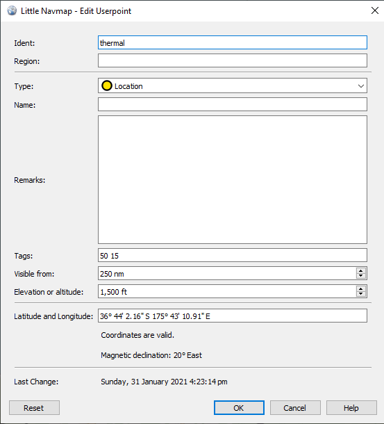
“1,500 ft” does not looks right (I guess that is your local system settings). can you paste CSV file here?
Sure, here
Location,thermal,-36.62434,175.55383,500,19.90157,0.5 5,250,2021-01-31T15:44:59.004,
Location,thermal,-36.68384,175.58130,0,19.93391,0.5 5,250,2021-01-31T15:45:02.670,
Location,thermal,-36.71136,175.75708,0,19.94013,0.5 5,250,2021-01-31T15:45:08.696,
Location,thermal,-36.72678,175.81201,0,19.94501,0.5 5,250,2021-01-31T15:45:11.285,
Location,thermal,-36.63757,175.81270,0,19.90020,0.5 5,250,2021-01-31T15:45:15.302,
Location,thermal,-36.63757,175.79073,0,19.90095,0.5 5,250,2021-01-31T15:45:18.318,
Location,thermal,-36.63013,175.78163,0,19.89747,0.5 5,250,2021-01-31T15:45:21.899,
Location,thermal,-36.61856,175.78781,0,19.89139,0.5 5,250,2021-01-31T15:45:25.126,
Location,thermal,-36.60244,175.78215,0,19.88335,0.5 5,250,2021-01-31T15:45:29.830,
Location,thermal,-36.59017,175.78317,0,19.87708,0.5 5,250,2021-01-31T15:45:33.509,
Location,thermal,-36.58314,175.77647,0,19.87365,0.5 5,250,2021-01-31T15:45:36.490,
Location,thermal,-36.58700,175.76309,0,19.87591,0.5 5,250,2021-01-31T15:45:39.854,
Location,thermal,-36.59251,175.75485,0,19.87893,0.5 5,250,2021-01-31T15:45:44.613,
Location,thermal,-36.60437,175.76738,0,19.88472,0.5 5,250,2021-01-31T15:45:47.389,
Location,thermal,-36.61332,175.80618,0,19.88822,0.5 5,250,2021-01-31T15:45:52.994,
Location,thermal,-36.61663,175.82352,0,19.88938,0.5 5,250,2021-01-31T15:45:55.818,
Location,thermal,-36.62297,175.82986,0,19.89235,0.5 5,250,2021-01-31T15:45:58.364,
Location,thermal,-36.63082,175.83365,0,19.89613,0.5 5,250,2021-01-31T15:46:00.974,
Location,thermal,-36.63702,175.82935,0,19.89936,0.5 5,250,2021-01-31T15:46:03.773,
Location,thermal,-36.62379,175.80412,1500,19.89355,50 10,250,2021-01-31T16:02:55.126,
Location,thermal,-36.74879,175.59338,0,19.96940,50 10,250,2021-01-31T16:02:43.213,
Location,thermal,-36.73888,175.74631,0,19.95494,50 10,250,2021-01-31T16:21:47.810,
Location,thermal,-36.72403,175.77721,0,19.94554,50 10,250,2021-01-31T16:21:54.683,
Location,thermal,-36.73393,175.71970,1500,19.95390,50 15 ,250,2021-01-31T16:23:14.251,
Location,thermal,-36.76034,175.70390,0,19.96876,50 15 ,250,2021-01-31T16:23:17.135,
Location,thermal,-36.71632,175.60210,0,19.95092,50 15 ,250,2021-01-31T16:36:05.435,
really weird, but your CSV missing a column. I am testing on version LNM 2.6.6. which one you have?
you can try to fix them manually, just change
Location,thermal
to
Location,,thermal
(extra comma so “thermal” is a column #3)
2.67 and will try that, thanks
I think it is the forum removed double comma, so it should be something else. I can try your file in the game tonight.
You mean 2.6.6.7 ![]()
My thermals now work with kinetic assistant v0.7
Okay, it was bad idea to paste code here as it became broken after forum formatting.
I have fixed issues manually, and it started to work, even if all thermals has 0 elevation (you sure you have set elevation properly?)
you can try file I have got anyway (be sure you are lower than 500ft so at least inversion effect can be triggered). rename .pln into .csv (forum does not allow csv upload)
mwr2410_thermals.pln (6.3 KB)

Hi @thealx2901,
thanks for the example .pln (.csv) file.
Can you give us a more detailed description of each of the datafields in a line of the provided .csv file please ? It seems there are way more parameters per line in your example file than in the official description. Maybe that needs an update.
Thank you for your work !
![]()
edit: nevermind, I was trying to create the csv by hand, I figure now it is way easier to use little Navmap.
you don’t need to build CSV in text editor, most data will be ignored by assistant anyway. LNM currently is only proper way to build thermals map.
It would be great if there was a way to choose the direction of the Aertow aircraft.
For example north, south, east or west. Not only north . ![]()
And that the ai-plane climbs a bit quicklyer at the beginning of the launch.
It flies through the trees und buildings near the airport, because it don’t climb up quickly.
2 Likes
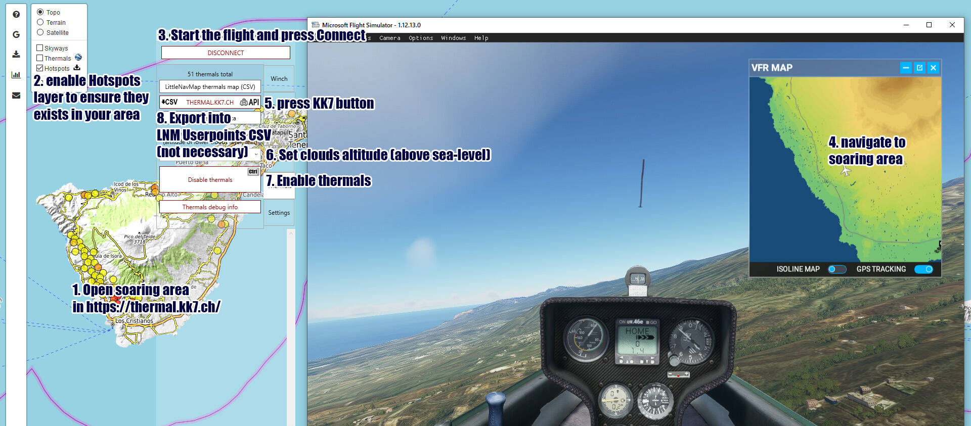
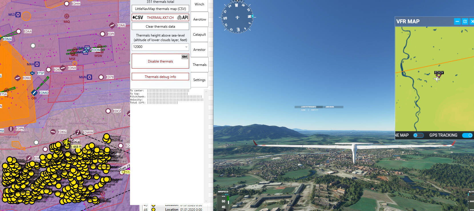
Kinetic Assistant 0.8 is out! Main changes - UI improvements, some bugs fixed and missing features added, and most important - thermals import from https://thermal.kk7.ch/ available now. No need to mess with CSV files. Just check their map for coverage, find suitable location, start the flight in MSFS and press the KK7 button on Thermals tab. To see thermals in LNM - you can export them as CSV and load by Userpoints > import section.
7.02.2021 Please update to v0.8.1 if you are using KK7 data
- transparency option
- partially working Always on top feature fixed
- Winch Initial acceleration field added
- Custom AI tow plane name support (most aircraft will not take off without taxiing; names list can be found in Developer menu → Aircraft Selector)
- Automatic thermals data load from thermal.kk7.ch service (experimental! coverage is limited, check their website to choose supported location)
- Thermals height field, for thermal.kk7.ch data or CSV thermals with 0 elevation set; should match altitude of lower clouds layer in the game (in feet)
- Thermal Clear button added, as now several sources can be used same time – multiple CSVs made in LittleNavMap and thermal.kk7.ch server data
- Thermal debug data moved into bottom window
- Winch/Tow rope random failures option (chances still depend on tension, Training Mode is like use damaged rope that will fail during next launch)
- AI tow plane altitude limit depend on launching position altitude (fix for mounting area)
Kinetic Assistant v0.8.2
- Always on top and Transparency checkboxes removed (available on the window bar)
- 20 seconds minimum KK7 data update interval (to prevent server flooding by possible code issue)
- KK7 thermals button state save (no need to toggle it after each program launch, just press Enable Thermals to start receive data)
- Solved KK7 data load precision issues, program will request data for single grid cell (3 on far north/south) to avoid clipping
- API thermals filtering, too keep distance between received hotspots
- API thermals maximum strength decreased
This tool is just great. I’ve tested it a little bit and sound really great. I wonder about the NORTH-GOING limitation for the AI plane.
Anyone has tested it with a mountain close in north direction? To use this feature in areas I know in the alps can be really painful due to very close big mountains. I don’t understand if AI is able to avoid mountains or not.
Thanks!
AI does not avoid hills, mountains or buildings, and that is real problem. Best chance you have with using Realistic option for AI towplanes, and start from parking. In this case plane will follow flight plan, which taking into account relief and runway heading. But, another issue here - most small airfields does not contain taxi paths, so either way it will not work in 30% of cases.
I do recommend to join some MSFS glider community, or participate in competitions - there you have good chance to find a live tow plane pilot.