Always good to read the trials, tribulations, and victories of your efforts to achieve your goals!
Best Wishes.
Just a short update…
It looks like I am 90% finished with perhaps 90% still to do ![]() as the saying goes…
as the saying goes…
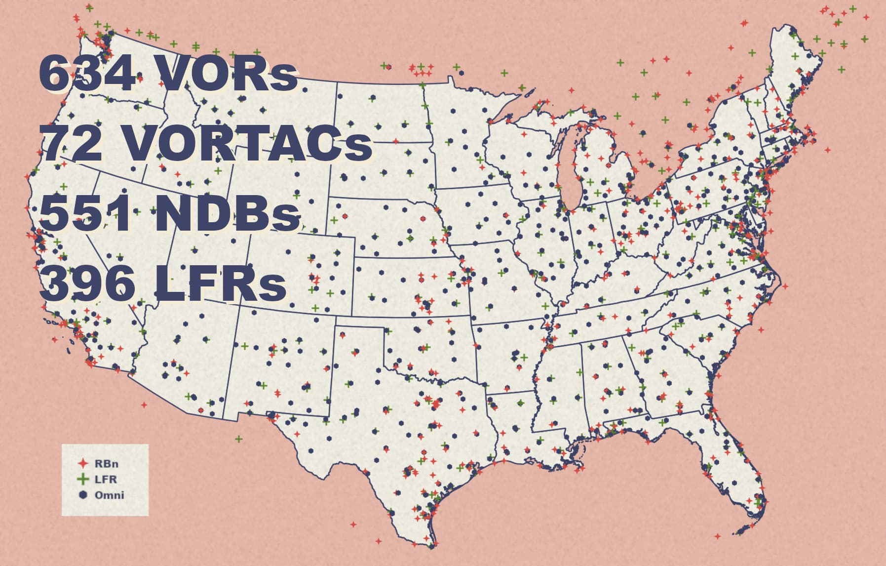
All navaids are in the sim together with correct magnetic variation and newly I got also all the ILSs working properly for the airports that had them in 1958, with correct final headings (magnetic) and glideslope pitch (which is why some PAPIs are now not aligned as for instance the old glideslope was 2.7 degrees while the PAPI is 3 degrees). Not a big deal. I also learnt that some airports or runways disappeared but such is life.
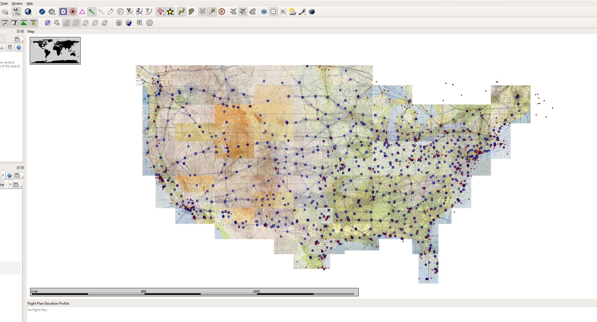
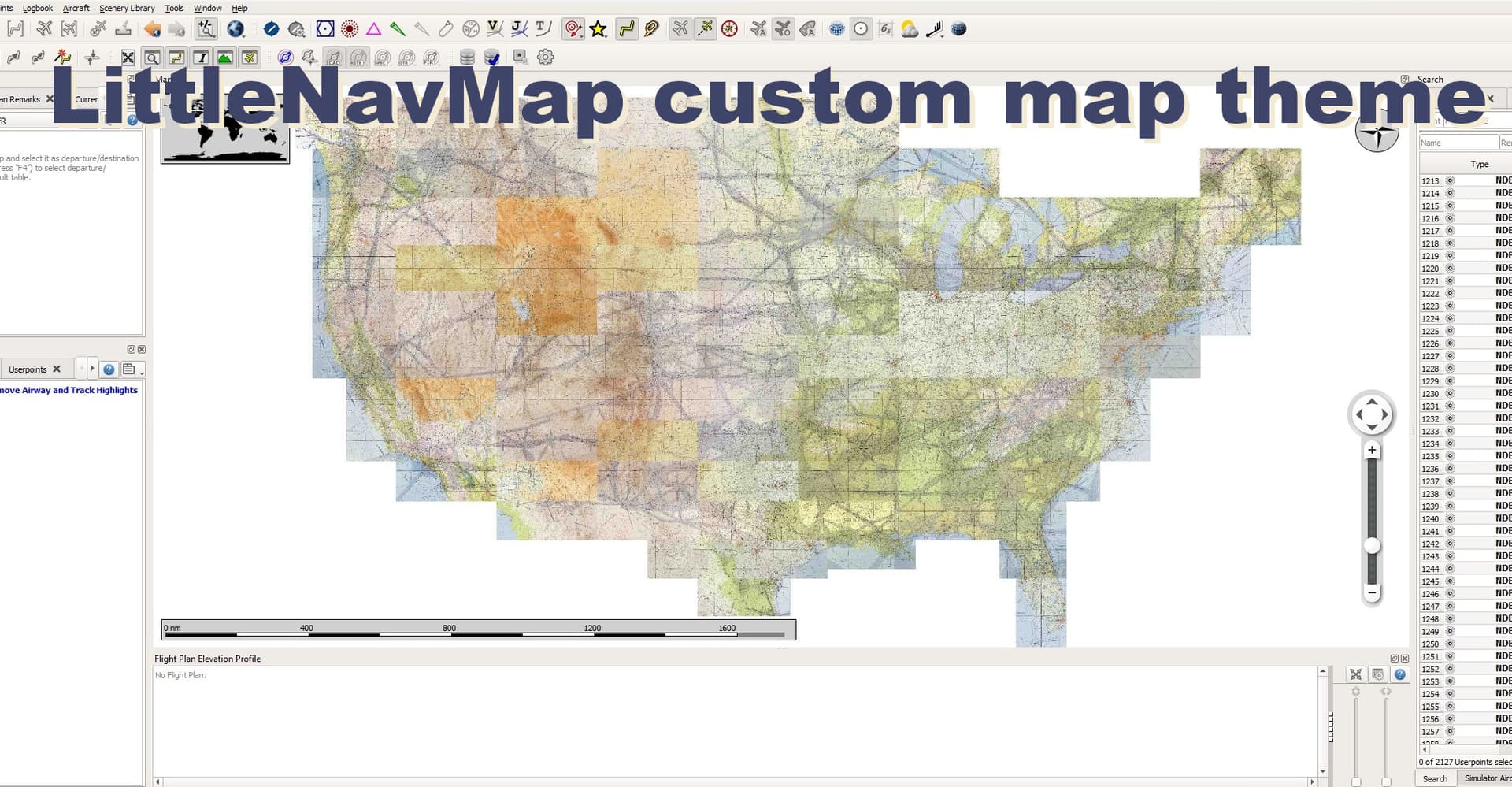
The picture below shows a qgis working screen with airports sporting ILSs in 1958.

There’s around 200 airports with ILSs depicted on the map so, while I will not bore you to death with details, I resorted to programming a visual basic macro in Excel to help me with processing the data (automatically as well as manually acquired) into the correct xml project files in the correct MSFS scenery file structure. Interesting stuff. Worked very well in the end and saved a bunch of hours ![]()
So in terms of actual navaids scenery there is not much left to be done (with exception of perhaps some fine tuning).
While testing, I work also on getting the sectionals into LittleNavMap in a way that is well readable but not too big (U.S. is a huge country and if you add Alaska to the equation…). It looks like yesterday I found a nice compromise so the whole of lower 48 is in the LNM and it looks great and works as it should. Check also the detail visible when zoomed in.

I am still thinking of how to get the 1958 navaids displayed properly in LNM. Since LNM does not allow for two different databases for one sim, possible options are:
- produce 1958-specific database for MSFS (shown in the two screenshots above) and let users swap it manually with the current one, or
- prepare a user waypoint csv file that could be uploaded to LNM
Both solutions have their pros and cons so in the end I will probably include both in the final package.
Low-frequency Range beams - this is still to be done. Probably will not pose a big challenge as I have already customized the radio range database for my other scenery: Flying the Hump
https://flightsim.to/file/43587/flying-the-hump
And that leaves us with the last bit of work to do…
…which is preparing the documentation (readme and associated historical publications) that will go out in the package. This will take some time and I want to do it properly.
So when should I be finished?
Probably still in the proverbial two weeks ![]()

Stay tuned.
In that regard, most of the modern approach light systems (ALS) will be somewhat inadequate for historical use as well. If you look at old aerials, you’ll see that most ALS used to be 3000’ long, whereas today they’re typically 2400’.
Why the difference? With a flatter 2.5°-2.75° glidepath, you’d be able/need to pick the lights up earlier at minimums. Once 3° became the prevalent GS, the last 600’ of the ALS became redundant because they’d either be under the nose or behind you as you break out at mins.
Thus, the majority of ALS in the US were 3000’ long ALSF-1 from the late 50s through the mid to late 70’s, when they started being replaced by MALSR or upgraded to ALSF-2 for CAT II/III runways. MALSR was implemented after a late-70’s study that showed little operational benefit from having the white light barrettes spaced every 100’ and extending to the end of the 3000’ ALS for CAT I operations.
That, along with the energy crisis of the time, allowed airports to drastically reduce the energy used, going from upwards of 180 PAR56 lights and 20 flashers (and all the associated land use needs) per ALSF-1 to 45 PAR36 with 5 flashers per MALSR. There are of course several other simplified ALS permutations that have been developed, and LED is now working its way into the picture.
Oh snap! Then we need someone to produce period correct sceneries as well… ![]()
Seriously… thank you for the information. What we are trying to achieve is to twist 2020 MSFS into 1958 MSFS which inevitably causes some discrepancies here and there.
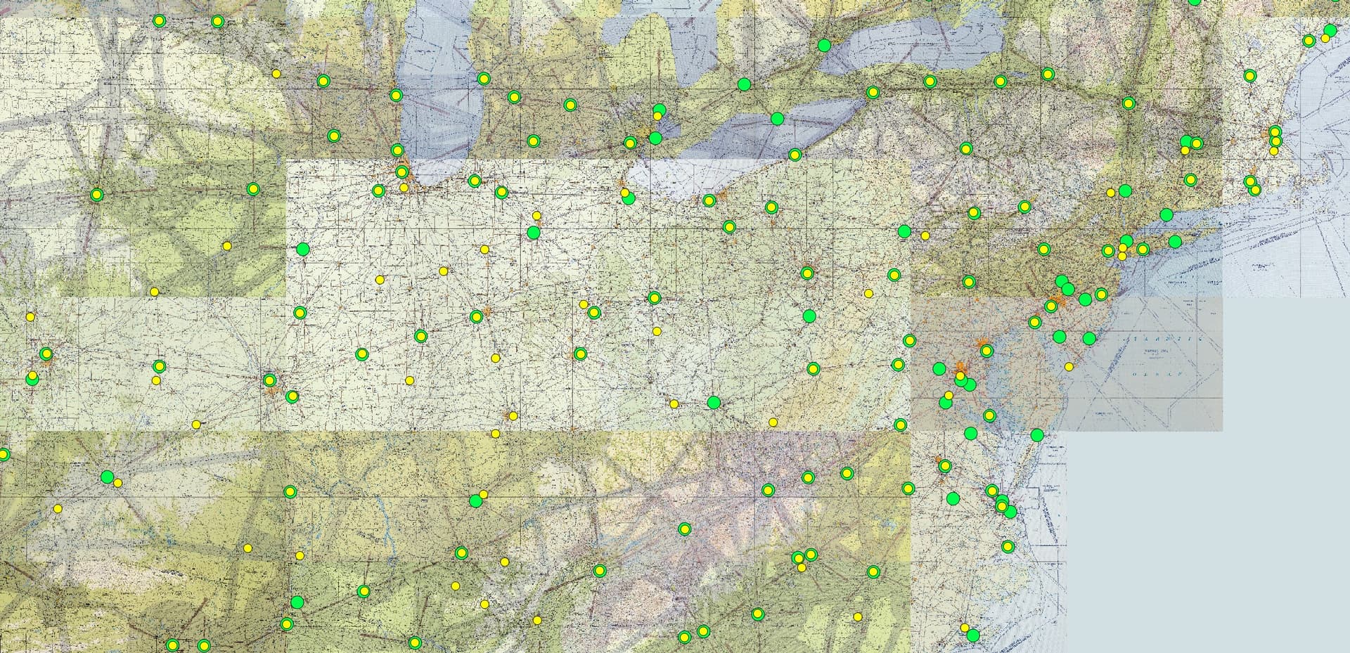
Btw. I am just working on aligning the Low-frequency Radio Range beams to the sectionals. The map below is the reason why this work is necessary (green circles are 1958 LFRs whereas the superimposed yellow circles are 1944 LFRs from the ElectronVolt’s addon; location only, many frequencies and directions of the beams differ as well):
I suppose I am done this evening and then do some testing.
No problem, I love stuff like this! It’s important to know where this all came from; it helps me feel like I understand the “why” behind things, which helps me retain knowledge, fly, teach, etc.
I imagine a big issue you’ll have with the ILS implementation is that the vast majority of runways have changed in some way or another. Many old runways no longer exist, many have been lengthened, shortened, or otherwise moved. And that’s beside the many, especially at larger airports, that have been added. I made a somewhat-related post on Reddit yesterday talking about how the entire practice of runway layout has evolved since WWII, through the advent of jet aircraft, to today.
Readme is (almost) done. I can see it needs few touches still but you can get an idea of what’s included ![]()
This looks excellent, thanks so much for taking on this effort. Also, I was today years old when I learned that “conterminous” is a word.
Tatadadaaaaa!

It’s out:
https://flightsim.to/file/71888/golden-age-of-air-travel-u-s-navaids-as-of-1958


Let me know please in case you encounter issues.
Thanks ![]()
Congratulations!
I’m looking forward to checking this out.
Brilliant. I will check this out as well!
He said 8 days ago…(was that an il2/Oleg Maddox "+2weeks"joke from back in 2002-ish by any chance?) Job well done, sir!
Thanks! Looking forwards to playing around with these! (downloading now!)
I am not sure myself but you may be right. It is an old running joke for sure ![]()
Two things:
One: this is amazing. It’s exactly what was I looking for, and I’ve very grateful for the work. I’m extra grateful for the clever integration with LNM.
Two: I am an idiot. I spent a lot of a flight troubleshooting my NAV radios because I couldn’t pick up any beacons. Turns out that while I did have USGAAT installed, I also was using Navigraph and their updated database, which completely overwrites USGAAT.
So remember kids, don’t mix your USGAAT with Navigraph AIRACs.
This is just super.
Does anyone know if any other projects are being worked on to do this sort of thing for other time periods or other regions?
Amazing work. Quick question, since it deletes all of the other navaids outside the U.S. when installed, how do you revert back to preinstallation navaids? Do you just remove the file from the community folder?
Exactly. As easy as that ![]()
And for the record, this mod will not function alongside Navigraph either.
Hey sorry, another question, while using this mod, is there anyway to find period accurate SID/STAR/Approach charts or are we just on our own for that one? I’ve tried a little digging and as far as I can tell the FAA didn’t really start producing those kind of charts until the mid 2000s? So everything prior that was done by NOAA, and I can’t find any historical database of terminal procedures.
Very nice prj!
I like these historical flights, we did on Vatsim long time ago some similar prj between our Slovak and Czech Division and had so much positive reports. In that times older than your prj some way was built as red light light towers just on one lets say street through Czech and Slovak territory. If I good remember, some BGL file was prepared with that towers and flights are very interesting.
Just one my quick idea after I see your prj - Lockheed Constellation ![]() This was the first aircraft I can imagine as right one for this fun, also DC-6 from PMDG but I don’t have them. Looks like, DC-3 can be enough to be satisfied in the air
This was the first aircraft I can imagine as right one for this fun, also DC-6 from PMDG but I don’t have them. Looks like, DC-3 can be enough to be satisfied in the air ![]()