Thank you for inspiring me! And thank you Co-pilot
Edit: List edited to latest layout (Of course Co-pilot made a few mistakes)
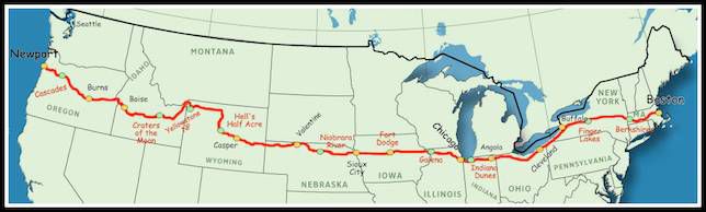
Airports Within ~10 Mile of US Route 20 (Grouped by State)
Massachusetts
US‑20 runs through Boston metro → Springfield → Pittsfield
Logan Intl (BOS) — Boston (~2 mi from US‑20 terminus)
Hanscom Field (BED) — Bedford
Norwood Memorial (OWD) — Norwood
Worcester Regional (ORH) — Worcester
Southbridge Muni (3B0) — Southbridge (small GA)
Westover ARB (CEF) — Chicopee
Westfield-Barnes Regional (BAF) — Westfield
Pittsfield Muni (PSF) - Pittsfield
New York
Route crosses southern/central NY (Finger Lakes / Capital region)
Buffalo, NY Skyline
South Albany (4B0)— (Small GA)
Albany Intl (ALB)— within corridor band east of Schenectady
Frankfort Highland (6B4) - Frankfort
Hamilton Muni (VGC) - Hamilton
Syracuse Hancock Intl (SYR) — slightly north but corridor-adjacent
Skaneateles Aerodrome (6B9) - Auburn
Finger Lakes Regional (0G7)- Cayuga
Canandaigua Airport (IUA) — near Finger Lakes corridor
Greater Rochester Intl (ROC)— within ~10–12 mi band
Geneseo Airport (D52) — Geneseo
Le Roy (5G0) - Le Roy
Lancaster Airport (LKP / KBQR area) — Lancaster GA fields
Buffalo Niagara Intl (BUF) — Buffalo (just north but within corridor zone)
Buffalo Airfield (9G0) - Buffalo
Chautauqua County Dunkirk (DKK) - Dunkirk
(NY has ~323 airports total, so density is very high near the route) [mapscaping.com]
Pennsylvania
Short segment near Erie
Erie Intl / Tom Ridge Field (ERI) — Erie (very close to US‑20)
Ohio
Route hugs Lake Erie and crosses northern Ohio
Cedar Point Amusement Park
NASA Space Environment
Sports Force Park, Sandusky (Old KSKY Airport grounds)
Burke Lakefront (BKL) — Cleveland lakefront
Cleveland Hopkins Intl (CLE) — within urban corridor
Lorain County Regional (LPR) — Elyria
Sandusky County Rgnl (S24) — Sandusky
Toledo Executive (TDZ)
Toledo Express (TOL) — west end
Indiana
North Indiana corridor (South Bend / Elkhart / Gary)
Goshen Municipal (GSH)
Elkhart Municipal (EKM)
South Bend Intl (SBN)
Michigan City Municipal (MGC)
Gary/Chicago Intl (GYY)
Illinois
Chicagoland corridor
Chicago Midway International (MDW)
Schaumburg Regional (06C)
Iowa
US‑20 closely parallels major GA fields across the state
Dubuque Regional (DBQ)
Independence Municipal (IIB)
Waterloo Regional (ALO)
Webster City Municipal (EBS)
Fort Dodge Regional (FOD)
Cherokee Municipal (CKP)
Le Mars Municipal (LRJ)
Sioux Gateway (SUX) — Sioux City
Nebraska
Northern Nebraska corridor
O’Neill Municipal (ONL)
Ainsworth Regional (ANW)
Miller Field (VTN)
Gordon Municipal (GRN)
Chadron Municipal (CDR)
Wyoming
Route passes through central WY
Lusk Municipal (LSK)
Converse County (DGW) Douglas, Wyoming
Casper/Natrona County Intl (CPR)
Hot Springs County / Thermopolis (HSG)
Worland Municipal (WRL)
South Big Horn County (GEY)
Yellowstone Regional (COD) — Cody
Montana (short segment)
Only a small stretch overlaps
West Yellowstone Airport (WYS) (edge case depending on routing variation)
Idaho
Crosses eastern → central Idaho
Driggs-Reed Memorial (DIJ) (near corridor split)
Rexburg–Madison County (RXE)
Idaho Falls Regional (IDA)
Mountain Home Municipal (U76) / KMUO Mountain Home
Boise Air Terminal (BOI)
Oregon
Longest single-state stretch, many GA fields
Ontario Municipal (ONO)
Burns Municipal (BNO)
Bend Municipal (BDN) / nearby Roberts Field (RDM slightly north)
Madras Municipal (S33)
Albany Municipal (S12)
Corvallis Municipal (CVO)
Newport Municipal (ONP) — near western terminus