Weather transition is not smooth after SU7

Yes, just experienced that myself. Tried a quick pattern around a small airfield close to my house. Right now, in the real world, we have a high layer of fog and just grey skies. In the sim there were blue skies as if the fog was ignored. In the pattern, when turning base, the fog suddendly loaded and I was unable to see anything. Perhaps the METAR Data is loaded later than the live weather?
How about this for a solution: Give us an option slider in the weather menu where we can choose if we want to use the “improved” METAR Data to “enhance” our weather. That way everybody can decide for themselves.
I, for my part, have been using VATSIM also frequently I never thought it odd when the weather was bit off - METARs are not always that accurate and from what real-life experience I have, I must say, also in the real world, METAR reports and real weather are not always 100% spot on.

I just went back to the main menu and started the same flight again. This time, the fog was correctly displayed right from the start. That supports my hypothesis that METARs are loaded too late.

1 Like

METAR will make the weather more accurate but not more realistic. Meteoblue will make it more realistic but not always accurate. I like to have it more realistic thats for sure. We can’t save the cookie and at the same time eat it up. A Sentence we use here in Sweden :slight_smile: I think it fits in well here.

2 Likes

Hence my suggestion to make it optional like DX12.

1 Like

If they do, what do you prefer they improve then? I would prefer they choose meteoblue and make it as accurate as possible, then we have a system that is as accurate and realistic as possible. With Metar in use we never will get it realistic in my opinion.

This is concerning. Based on how the devs described the new weather data, this shouldn’t be happening. MeteoBlue should be blending METAR data with their model forecast so that there is a single data source and transitions should be relatively smooth. The reports of abrupt transitions and haze layers suddenly appearing and disappearing make it sound like the blending process is either too heavily weighted toward METARs or worse: METARs are being injected into the sim as a separate data source with no blending.

2 Likes

I wonder how this blending is done realy. It sounds to good to be true in my ears. It sounds like a real tricky thing to do. How do we blend clear weather with overcast weather? Sometime it needs to switch. It needs many variables because dynamic weather has many variables. Metar has just one because it’s static.

I was flying vfr around some Colorado hills last night, the temp was hovering around 0C +/- a little and the ground kept changing from green trees to snow-covered in an instant. Luckily no insta-fog. It happened back and forth probably 8 or 9 times in a 1 hour flight. One of the changes went to snow covered on short final, the whole airport turned white :face_with_symbols_over_mouth:

This is what i was afraid of in the beginning. People were complaining about the weather system not relying on METAR. But the problem with METAR is it’s local and you get sudden weather changes during flight which break immersion.

I rather have realistic dynamic weather than correct live weather with clouds instantly popping in and out.

10 Likes

The issue after SU7 acutally is, that now the weather which momentary is at the weather station in which area you are currently flying will be displaey for hundreds and hundreds of milles to the horizon on each side of your plane. When entering the area of the next weather station, the local weather there is again displayed all over the world.
Slew yourself up to 40000 ft and you will e.g. seecumulus all over the world. Then when entering an area with clear skies you will suddenly have clear skies all over the world, also there where you had cumulus just 5 seconds before.
Before SU7 you could e. g. fly through clear skies seeing building up thunderstorms in the distance to the right and layers of stratus to the far left, with smooth, realistic changes when entering one of these ereas. This was as real as it gets. Meteo Blue had done a really good job in calculating the weather in between stations. It really is a shame that all this (for me one of the best features MSFS had) is gone now. Weather in MSFS is after SU7 as unrealistic as it is all the other sims.
I hinstantly hope this is only a bug and not intented. I also hope MS/Asobe have not cancelled their colaboration with Meto Blue.

PS: “thank you” to the moaners who were complaining mSFS wetaher was not always stright to metars. I for myself will probably take a hiatus from MSFS until this is fixed.
And to MS/Asobo: please do not always listen to those who scream the loudest.

10 Likes

so from what I have seen from my test flights, I don’t see any forecast data involved - It just looks like a metar engine is always acting - no cloud bands visible - it’s always just less cumulus or more cumulus “gathering” around the respective METAR stations - to be honest I have also installed the new update REX Weather Force 2020 - and this one seems to handle It better - the flight was only short - would have to test further. but that’s exactly what I don’t want anymore.

and here’s another example of the “great accurate METAR” (meant ironically if we’re talking about “accurate”):
Let’s take not only current stations (large airports) but also those that are no longer current - or are not occupied (at the moment) - smaller airports etc. - Let’s take an example of a small airport in our beautiful Austria
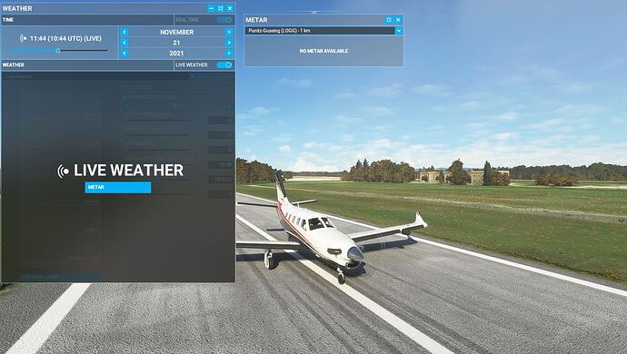
LOAR at 11:30:

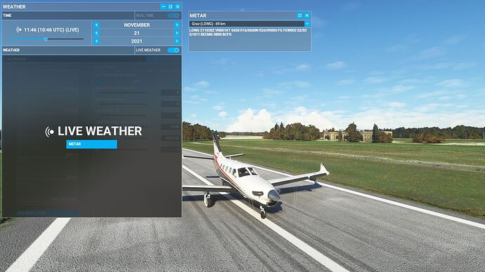
ok there is no METAR data, the next current station is LOWG (the only active one in the radius selectable):

so what data are taken over there or what is interpolated there ? the station is 69 km (~37 nm) - in this radius there is no current data - so what is set or interpolated is what prevails there and that is 37 nm and there the weather can deviate by “worlds”.
By the way, with REX it looks the same - because REX also uses the data from the next active station and in this case LOWG !

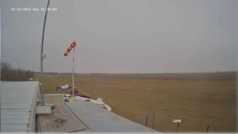
and this is how it looked on the webcam at the same time:

test9

So when you talk about the “suitability” of METAR, you should also take this into account and admit that it is also nothing for people who “first” operate VFR.
this is also one of the reasons why metar is not usable as a “visual” “option” for the SIM as the only source (which does not mean that you cannot use the values as a addition) !

The question is - do you want to have weather that is not really accurate but with sudden transitions - or weather that is not always accurate but smooth - would tend to the last option !!! (ONLY)!

And if the forecast is even better or more accurate in the future updates - there’s nothing to complain about!
The problem is still there with the visibility layer (or haze) - but you can read it out of the METAR - it would be important that everything comes from one “source” - otherwise a smooth transition is goodbye !
Besides, I would take these low level clouds (partly done before SU7) - because this “3D” fog is much easier to control or to set. !

And I must say REX MSFS2020 does the job really well - and if the update of unreal weather mod is also there - so where is the problem ? (I mean people who really want to have METAR based weather - can use these tools !!!)

2 Likes

Please read my post above and you know, where the problem is. When looking out of a cockpit window in rela world, you won’t see the same kind of weather up to the horizon. This is totally unrealistic.

thank you, there is the addition to my upper post ! :+1:

The problem is using METARS. REX and Unrealweather using it too. They need to change somwhere. Thats why they have a transission time inplace and sets the current weather everywhere with no other weather around until we come close to another station and then it will transision to that weather instead everywhere. In that system we can’t see cloud fronts as we can with meteoblue. Meteoblue have global weather. METAR is local static weather put everywhere in the sim. Makes the weather feel static and not dynamic.

Have both in place will destroy the dynamic part of the weather how much work they even put in it. I used Active sky in fsx. Same problem there. They can make it better but it will always feel static because METAR is static.

I think volumetric clouds not fits well with static weather. It looks more unrealistic when something decides where to put those on a radius or whatever they choose. The higher we fly the more worse it looks.

1 Like

In my opinion, the underlying problem is not with static vs. dynamic data. In all likelihood, the MeteoBlue data is delivered in static snapshots just like METAR data. The sim appears to have a system to make the static data more dynamic – individual clouds build and dissipate, precipitation moves, etc. But most forecast model data is produced in static snapshots on a regular time interval (every hour, every three hours, etc). In principle, METAR data can be blended into these model snapshots to produce a blended dataset that will still morph overtime just like the pre-SU7 weather.

But like you mentioned a few posts ago, blending the two is EXTREMELY difficult in practice. The biggest problem is data resolution. Weather conditions at a local airport are often influenced by extremely localized phenomena: terrain, small-scale features of passing storm systems, etc. Global weather model data doesn’t have sufficiently high resolution to depict localized weather. When meteorologists try to blend low-resolution global model data with individual local METARs, the resulting data is going to have some features that don’t look realistic. It’s an inevitable result of trying to mesh together low resolution data with randomly scattered data points (METARs) that don’t match it.

2 Likes

I agree, thats why i think they should choose one system instead and improve on that. It must be harder to improve it now when they have two systems in place that needs to work at the same time. Do we need it to be accurate all the time? I think the most important is that it matches between the users and that the weather occuring in the sim is possible at that location.

1 Like

Here’s how I would summarize the problems MeteoBlue is facing:

Low-resolution global weather model data can produce a good, realistic depiction of storm systems, fronts, and large-scale weather. For cross-country flying at high altitudes, this is all that is necessary. But for low-altitude VFR flying or IFR approaches and departures, global model data has glaring inaccuracies. Here are some things I’ve noticed in working with the US GFS global model as a meteorologist:

  • Low-level clouds (especially stratus) are very inaccurate. The GFS tends to produce either fog or no clouds. Persistent, widespread stratus is not accurately simulated.
  • Thin fog (mist) is completely missing. The model simply does not depict it or forecast it. It will either put a cloud on the ground (thick fog) or have good visibility unless precipitation is falling. This is exactly how weather looked in MSFS prior to SU7.
  • Haze (smoke or other air pollution related particles) is completely missing from model forecasts. The only things that will affect model visibility are clouds and precipitation.
  • Thunderstorms are not directly simulated. The model can calculate the probability of thunderstorms and the average effect of the storm on the broader atmosphere, but it cannot depict the structure of the storm with any accuracy. This corresponds with MSFS showing lightning with scattered fair weather cumulus clouds at times. In those cases, the model probably indicates an elevated probability of thunder, but its cloud and moisture data do not depict a realistic storm.
  • Terrain-related phenomena (valley fog, mountain-induced clouds and precipitation) are not always correct and sometimes completely missing due to the low resolution of the model.

Overall, while global model data is physically realistic and depicts large scale features well, it has some glaring deficiencies. It will not depict some of the most important types of weather that pilots deal with regularly. So, in my view, some sort of blend between multiple data types is probably preferable, if it could be done well.

High resolution weather models improve on the above points in a few ways:

  • Low-level clouds are more accurate (but far from perfect)
  • Thunderstorms are directly simulated, with realistic structure
  • Terrain-related phenomena (mountain-induced clouds, etc) are far more accurate

But even high-resolution models generally do not simulate haze and mist. Visibility remains very good in the model unless clouds are on the ground or precipitation is falling. High-resolution models are also regional. It requires too much computing power to run a high-resolution simulation for the entire earth. So high-res models usually cover a small subset of the earth. If MeteoBlue incorporated high-res data, they would need to blend it with low-res global data to provide worldwide coverage. The transition from one dataset to another would be hard to smooth out. This is a thorny problem all the way around. But overall, I think it’s the right call to begin blending multiple datasets together. No single dataset has everything necessary to make a realistic flying experience.

In my view, the main problem in SU7 is that the newly-developed data blend was not ready for primetime. It needs a lot more work to make the blend realistic. This should have been kept out of SU7 until MeteoBlue could improve it further. But the general direction they are heading is correct, in my view.

6 Likes

And this is precisely why I am suggesting to use historic data as in 24 or even 48 hour old weather, because this way the weather engine can anticipate and has more data to work with to produce a smooth transition from one weather condition to another. Think of it as a flight path determined by points. If the path only knows the next point you will have a path with harsh turn, when the point after the next one is at a 90 degree angle. If you consider the next and the point after the next one, the path can adjust the path so make the turn more efficiently and natural.

I am no programmer. I only rely on incomplete information by others. But I imagine a weather based on real-life weather (currently) to only be able to rely on “points” for an accurate real-world weather snapshot.

Let me perhaps try again to convince more users around the hard-core base why I believe we shouldn’t be too picky about having the exact same conditions in the simulator at the exact same time we are observing outside our windows.

First of all real world weather is real world wather and doesn’t matter if it’s 2 hours or 2 days old. It still is real world weather. An IFR conndition at EDDF is just as realistic as a CAVOK condition at EDDF. Neither a 234/04 wind nor a 164/10G25 wind fail the test on it being real world weather.
Any condition that can happen at a given location in the real-world CAN be considered real-world weather.

Let’s talk about the term “live”. It seems there might be two different views on what that word means. To some “live” is the equivalent to a sports game being live as in you want to be watching it as they play.
The other meaning (the one I prefer) akin to being “alive” as in acting the way it should be like the real-world weather.
With our current “consumer” technology it appears having both versions of “live” is not possible.

What I feel IS possible however is having a fully dynamic and atmosphere engine that can very well imitate real world weather conditions. I mean it certainly fooled me pre-7.
The previous way of injecting weather had a lot need for tweaking and fine-tuning, but to me it was meant to be the new norm.
I truly believe it IS possible to have a fully dynamic and believable weather engine and provide METAR data. But the METAR and TAF data should be dictated by the simulator weather engine (which would still use real world weather data as a baseline) and not have it the other way around. And yes have it 24 or 48 hours old for it to smoothly transition from one state to another and anticipate better what do do next.
Why 24 or 48?? Because this way we still have time of day (morning/evening) typical weather conditions and still be true to seasons. A typical 21st of November weather is akin to a typical 23rd of November weather for any location.

The only and really only(!!!) reason one would be so persistent to have “live” weather akin to watching a live sports event is for online flying purposes. And for this reason I believe the source for online networks should shift where progress is being made and use METAR and forecasts that are being created within MSFS weather engine. Again this is weather still using real world weather. 24 or 48 hour old real world weather is still real world weather as it’s source. It is just using different techniques to depict it. I see the community as whole, which includes VATSIM, XP, P3D and MSFS. And I believe if progress is being made somewhere, this should be the standard. If MSFS can provide a superior way of simulating weather than online networks should adapt to it, rather than MSFS being forced to adapt to other if progress is halted or even regress is necessary or any other form of bending that causes unwanted and unrealistic side-effects. For a P3D simmer, which weather engine heavily relies on METAR data it doesn’t really matter if these parameters come from the NOAA or from MSFS generated weather, which on it’s own is still using real-world data. So real-world weather data still is provided through a different route and on a different timeline.
Instead of flying with 21/11/21 weather on the 21st, we’d be flying with 19/11/21 weather on the 21st. What difference does it make if “everyone” within the community is using and flying on 19/11/21 weather on the 21st. What difference does it make if everyone within the community is flying in IFR conditions at EDDF, while it’s CAVOK outside?

I am in for any kind of smoothing to get the best of both worlds. What I don’t want to back to however is “weather condition bubbles” around the aircraft. That was one of the best things about MSFS weather. Being able to see the different types of weather conditions from a distance and fly into it. Or see that kind of weather approaching you, while you’re still on the ground. I remember experiencing a change in weather from few clouds to nearly overcast with a transition so seamless I was like a little kid in a toystore.

3 Likes

How can they manage that with METAR is my question? That is the thing we all like with the dynamic weather. Now many want’s to have it static to be able to use VATSIM. I also liked the varied windspeed that was in the sim at release until the su4 got released. I think it was in that the wind got METAR based and static too.

Asobo needs to make it generate own METARS of the weather or something. Or why do we need METAR. Can’t those who controlling in VATSIM start up the sim and look how the weather is at that airport when using?

You made a lot of good points here. I think your insight is correct that a blended data product will be more accurate with smoother changes over time if it uses historical conditions rather than current conditions. The best blended analyses of meteorological data usually have a time lag to take advantage of the most available data and run a high-quality computational blending process.

It will not be possible to produce a perfect system that seamlessly includes both 3-D global model data and 100% accurate conditions at all world airports without any unrealistic artifacts, but the closest way to get there is to use historical data and run a high-quality computer-intensive analysis to smooth out the data. On the other hand, if the community would prefer a depiction of the most recent weather, we will need to accept one of two options: either the weather will not always match the METARs, or there will be unrealistic artifacts in the data in order to force the global model data to match local conditions.

My personal preference is to have current weather with a blended system that nudges the model data to be closer to METARs while smoothing out inconsistencies. This will result in plenty of examples where the sim weather doesn’t match the METAR, but it would be more accurate on average than model data alone. There is no perfect solution here.

I enjoy being able to plan a flight by looking at current weather data, so I would prefer current over historical data. I fully understand that I’m accepting some inaccuracy in the details in order to fly in conditions that generally reflect the current weather.

What about injecting SEPARATELY, meteoblue global data + metar’s visibility?: