Indeed, unless you are an actual pilot with experience on the G1000 NXi, it might be more productive to assume you are making a mistake instead of assuming that the G1000 is producing “garbage”. I realize MSFS is not perfect, but that attitude is not productive.
Hi and thank you Matt, for going to the trouble of looking into this for me and for your considered response.
Yes you are right, I am not an expert, but I thought I had a good basic knowledge of msfs.and autopilot.
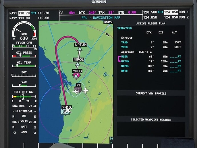
However, when I set YPAD to YPED in msfs Maps, using the standard default msfs G1000 it automatically adds the transition to the approach and and the vectors to final is an arc not a sharp acute turn, which is far more practical, as can be seen below:
Seondly the original GS1000 automatically also automatically loads and selects the route/tranisiton to the approach.
If the whole idea of msfs Maps is to map out a complete route in this case, YPAD to YPED plus add an approach and it confirms both of these on the on the map route displayed, I dont unndersatnd why your NXI G1000 doesnt load the route to the approach when it is shown as such on the map. What is the purpose of only loading half the flight plan without the transition to get to the approach?
This is what I had assumed had been loaded (ie transition to approach plus approach) when I used the NXI and when it wasnt getting me to the transition to the approach, so I thought (wrongly) the whole thing just wasnt working the way its meant to.
As I said earlier it doesnt make sense with NXI to map out a complete route in msfs Maps and is misleadingly shown as such,but then when you begin flying you actually have to manually add the first leg to get to the approach? Am I missing something here???
Hope you can see my point, and why I had assumed NXI just wasnt working properly.
The biggest takeaway here is that the world map and the original G1000 have some limitations:
- The big swooping arc shown on the G1000 is completely synthetically constructed; it does not appear anywhere on the approach chart for ILS 18 Z, and is actually synthesized by the sim entirely, not connected to any waypoint you can add to the flight plan. When loading the plan you have listed, no real world instrument I can think of would add this massive arc to the final approach course, unless that arc was part of the selected approach procedure.
- The world map does not allow a user to specifically set an approach transition at this time. Instead, it picks the approach transition that would connect it from the previous waypoints or arrival in the plan. In this case, from this angle, there is no obvious transition available on ILS 18 Z, so the sim picks “no transition”, and that’s what it sends us when the flight loads.
- Despite what the world map shows (a connected line from YPAD to UPTUN), that’s just an approximation of the real flight plan, not taking into account any plan discontinuities, manual sequence legs, procedure turns, or holds.
Future marketing material:
“When you want to play a game, use the original G1000. But when you want to sim? Pick the WT G1000NXi.”
(I’ll see myself out.)
You do realize when SU10 comes out in a week or so, the G1000 NXI is going to be the DEFAULT in game?
Very good news.
I think you were responding to me. Indeed I do, and I can’t wait. It’s an awesome work of software engineering.
Thankyou for your reply.
This is really helpful in now better understanding how NXI is treated in maps and why I believed it didn’t appear to be working properly. I will now retry with this new information in hand.
Cheers.
I love this little teaser of what is coming down the road. ![]()
Does anyone know if the G1000 (and other WT projects) will show offline AI traffic in the future? I asked on the Discord channel and someone told me it was coming in SU10, but I’m using the current beta and do not see the traffic.
I am using AI traffic with the Simple Traffic and Offline GA traffic mods and it’s exactly what I have been looking for.
A curiosity: is there anything faster than the Kodiak that uses this, available in the marketplace?
Hi All,
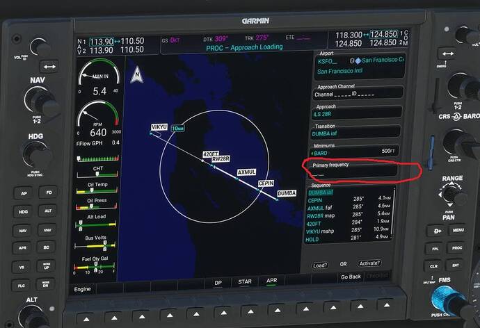
I am flying the Default Beechcraft G36 in MSFS with the addon Garmin G1000Nxi on a flight from KSAN to KSFO RW28R.
My issue is, when entering Approach to RWY 28 R at KSFO, ILS Frequency for runway does not show up the “Primary Frequency” Box, which is empty.
I have the latest Navigraph data base installed and running SU9.
Any ideas on what is going wrong, is this a database issue?
Bill Clark
Looks like ILS 28R is missing in the database. I get the same thing and I don’t have Navigraph.
Somebody should create a bug report
It’s been done…
There is a problem with default and 3rd party airports.
However, I can manually capture the Localizer and later the GS, but it doesn’t always hold the GS on the flight path. Sometimes I have to use v/s to descend down to recapture the GS. You have to be careful when lowering speed, flaps and gear, which can upset the ILS stability.
Hopefully it will be fixed in SU 10?
The G1000NXi is working perfectly. Nothing is planned to change in SU10. If there is a problem capturing glideslope, there is some other problem. Probably pilot error
Pitch and power determine an aircraft’s altitude. Decrease pitch and power to descend. In GA aircraft there isn’t an AutoThrottle. The pilot is responsible for the power while the autopilot sets the pitch. When the glideslope or path are captured, the autopilot will move the trim to stay on the glideslope. The pilot has to change the power to stay on the glideslope. As flaps are added, the flaps change the pitch of the aircraft so then the autopilot adjusts the trim to stay on the glideslope. The aircraft’s airspeed decreases due to the autopilot trim and flaps additional drag. The autopilot can only change the trim a certain amount. If the pilot doesn’t take any action, the airspeed will decrease too much and the aircraft stalls while the autopilot disconnects.
Pitch and power always act together. If you are having a problem with the FMC/autopilot not tracking the glideslope correctly, turn off the autopilot and the flight director and fly the approach manually. Try staying within one dot of the vertical and horizontal center points. And while you are descending, lower your airspeed for landing while staying on the glideslope. For an additional challenge, set the weather cloud base to maybe 100 ft above minimums.
The bigger jets and airliners have an AutoThrottle. When the glideslope is captured, the autopilot changes BOTH the power and pitch. Much easier!
You are better off setting flaps and gear shortly before you capture the glide slope.
Which plane?

