As there seem to be so many “issues” around WU6 I can not say if this has been reported before, but …
Flying from EDDF to EDDK along the river Rhein I noticed that at some point the trees were gone.
Very sporadic “bushes” do exist … but other than that the forrests are just plain sat images.
Other 3D features are there … houses, power line poles, etc. … but not trees.
Setup:
PC, 4K Ultra, 200 MBit uplink,
For anyone who wants to contribute on this issue, Click on the button below to use this template:
Do you have the same issue if you follow the OP’s steps to reproduce it?
Provide extra information to complete the original description of the issue:
If relevant, provide additional screenshots/video:
Can you be more specific by either giving coordinates one can punch into the map or by naming town names near the phenomenon?
I just flew from Bonn to Mainz and didn’t notice any major patches with missing trees.
Rather the opposite, I had some on approaches that shouldn’t be there.
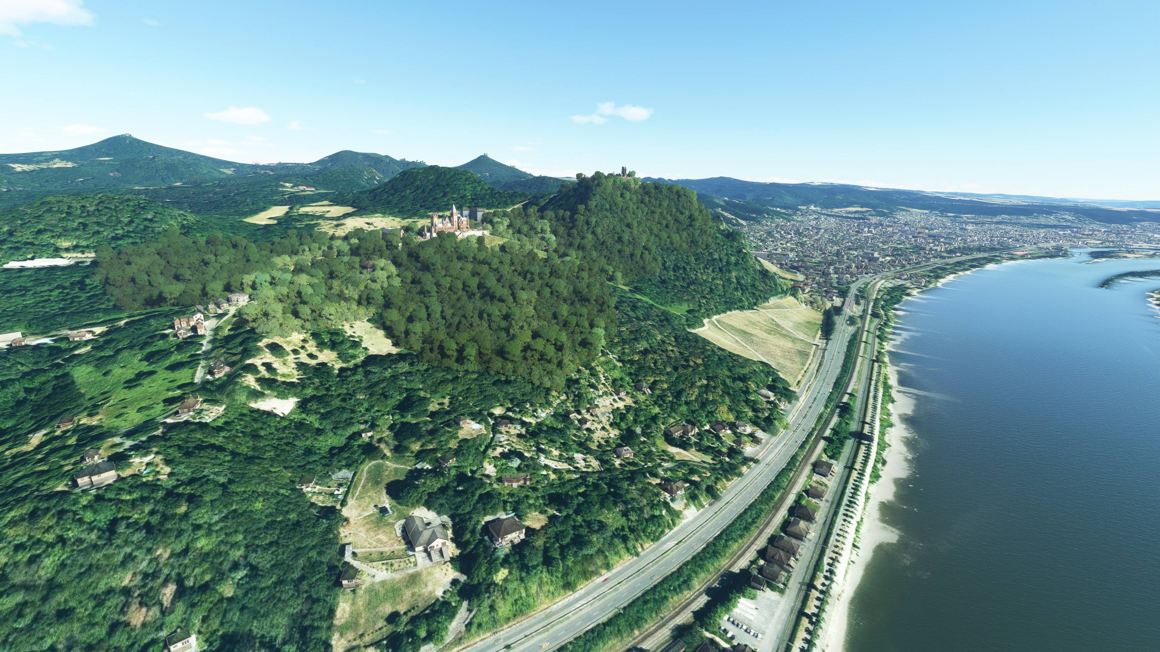
The “tree less” landscape for me started prior to Bingen … and lasted to Bonn.
Here is a picture from a mountain north of Koblenz looking south towards Koblenz:
Yes, as you say trees are sparse from north Koblenz down the Rhine to at least Wiesbaden. But buildings and other added assets also look to be simimarly sparse.
I think the problem is more that the Bing maps used are so poor in quality that MSFS just can’t interpret and add what’s required where.
Yes, (as always) I did clear and rebuild the cache … but I will retry at a different time. Perhaps some of the Bing server are overloaded these days … and that causes high latency … which cause request termination.
But that explanation somehow would not explain the houses and bushes which I do see. IMHO they indicate that I did receive “3D asset info” for those tiles.
Maybe the data replication between the servers has not been fully complete … and so no everybody gets the same data.
Who knows what is going on?
I have noticed with the new 3D asset info that I get way more trees than there should be there.
I see them in the midst of agricultural fields, I see them on airport grounds where they shouldn’t be.
The problem with the missing trees exists in large parts of Germany where there are new Bing aerial images with pale colors or relatively little contrast.
It can be seen quite extremely, for example, in the large forest area directly north of Würzburg (Bavaria), where there are high-contrast aerial images in the west and low-contrast ones in the east. The western forest area looks normal with dense trees. Exactly at the border of the low contrast aerial images, the trees are missing by more than 90%.
It looks terrible and stretches over huge areas.
The immersion is completely gone.
I don’t think the problem can be fixed easily and it has nothing to do with server overload.
Clearly … the new hand made (castle) assets have trees … but the auto generated landscape does not.
So I totally disable the Rolling Cache and retried 20 min. later …
But as I already wrote … I did delete the cache prior to my first WU6 flights. So to me it seems like the replication of the multi-Petabyte Azure backend world data was (is?) not fully rolled out to all servers in the same level.
Seems like this time my server had the data. So this “bug” in this area seems resolved (at least for me)
Noticed a tree issue everywhere in Germany.
When it switches to the highest level of ground texture then suddenly trees disappear.
Saw it north of Frankfurt, north of Stuttgart…
Trees come back when texture switches back.
After WU6 i noticed a lot of vegatation issues in Germany.
Trees disappear in many areas.
This occurs when ground texture is swichting to a different resolution. You can clearly see the difference in content and resolution. At the same time all trees disappear completely.
So flying closer to the ground elimantes all trees.
When ground texture switches back (to lower res) then trees suddenly come back.
Saw it north of Frankfurt, north east of Stuttgart (close to Weissach im Tal), Wolfsburg.
I loaded the flight(s) multiple times. Same issue always.
Buildings on the other hand don’t disappear.
What actually is interesting here is IMHO … Germany typically has very detailed OpenStreetMap data with very good land use tagging. So “detecting” a forest is not that hard in most cases (= does not require an AI checking the sat image).
The same goes for agriculture land use … OSM is a pretty good source. Yet I do see lots of trees growing in the middle of a corn field … and the forest to the right and behind is more or less empty.