I don’t think “settings” are an issue. I did a few minutes of various discovery flights, one after the other with the same settings. In every case, the cities looked way better than the Canadian cities in WU11. The buildings were crisp and clear, not muddied and deformed as we see in this update.
1 Like
Sounds more fun in California, squeezing 32 people into a pool ![]()
2 Likes
Are you able to divulge particulars about the mod you’ve mentioned, the one about the Rocher Percé and other areas nearby? Thanks.
1 Like
So it is true! MSFS has taught me something unexpected, thank you for confirming it is actually true. I thought it could be, but it still seems surprising so far up north.
Merci / Thanks.
1 Like
Seems like a big cost, and a lot of effort to have a pool there, considering summer is basically the second week in July. ![]()
All I can say is at some point there was a pool salesman in Quebec that could sell solar power to the dark side of the moon.
1 Like
![]() Hahahahahaha. Perfect.
Hahahahahaha. Perfect.
You do realise that the dark side of the moon is so called not because it receives no light, but because it faces away from the Earth at all times?
The so called dark side of the moon does, in fact, receive its fair share of sunlight.
Hello everyone,
While I’m personally finding this conversation about the dark side of the moon and rates of pool ownership in Quebec genuinely fascinating, please keep this thread on-topic for discussion and feedback about the Canada World Update.
Thanks,
MSFS Team
11 Likes
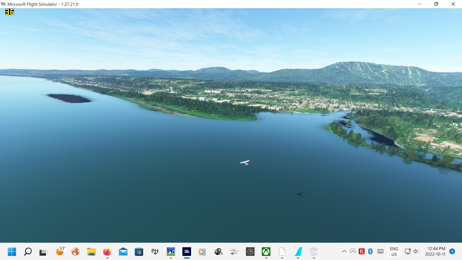
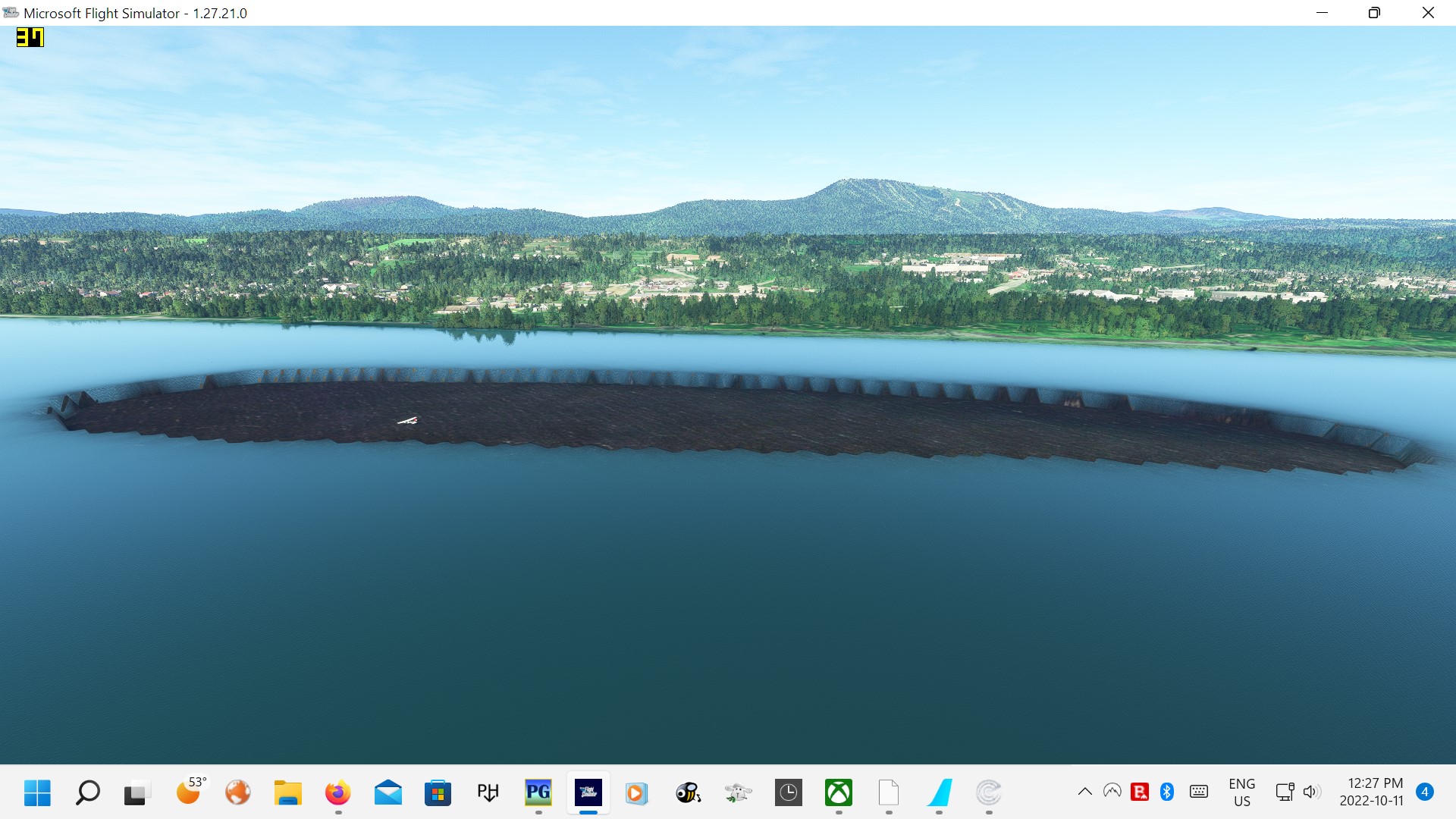
Well, SeedyL3205, you asked for help pinpointing the locations of scenery flaws so here goes. I thought the Canada Update had taken care of all elevation problems near Quebec City’s Ile d’Orléans and Mont-Sainte-Anne but I was wrong. I took these screenshots as I flew westward toward Québec between the island and the Saint-Lawrence River’s north shore, near the Mont-Sainte-Anne ski resort. From a distance, it looked like a hole or trough in the water and, curious, I landed in it. The screenshots tell the story but, strangely, if you look at my last one, the Plan-G app shows my aircraft sitting over, well, something, with the exact same shape. This aberration is visible in OpenStreetMap and it also appears as some kind of shallow area in Google Maps’s default view. I first flew this route on the day the Canada Update landed and I don’t remember seeing this problem on that day. Per the MSFS Team’s request, here are the coordinates: 45 km north-east of CYQB and Lat: N46º 56’13.69” Lon: Wº 24’ 16.24” Apologies if somebody else has already reported this error.
Don’t get me wrong, I love the Canada Upgrade despite its many flaws; it’s too bad it spawned with errors galore but it has worked mostly well for me around Montréal and down river to Québec. It will get better.


4 Likes
I had been away from MSFS for a couple of months and just returned to it this week. I had to reinstall it when my pc’s Windows 10 became corrupted requiring a reinstall while keeping my files. After reinstalling MSFS2020, I loaded up my previous scenery and aircraft addons. I ran the updates including the World Update XI: Canada. I loaded into my home airport in Dorval (Montreal) Quebec and was pleased that the aircraft worked perfectly. I took off and noticed how much richer the scenery seemed to be but as I got closer to downtown Montreal, I was blown away by the corrections and increased quality of the scenery. It was very humbling to see the Jacques Cartier Bridge now properly portrayed in all its glory without the horrible “wall” under it as in previous versions. But what really put the lump in my throat was seeing the Cross on Mount Royal and the TV tower in their proper places after so much disappointment over the past 2 years that I have been flying MSFS. I am very eager to revisit other cities in Canada and in other countries after seeing the great improvements in this Canadian update.
I want to thank the Microsoft MSFS team for making these corrections and for improving the best flight simulator on the planet at this time.
Much appreciated everyone.
1 Like
You can bet a dime that “noise reduction” is exactly what those “mesh cleanup algorithms” are trying to achieve - since years. That’s a big topic of research in computer graphics (among other “hot topics”).
So if you have any good ideas / algorithms / AI systems: feel free to make them public and/or do a PhD thesis about them. Or even better: get a well-paid (?) job in the computer graphics industry ![]()
Here are a few pointers to get you started (randomly collected):
- Local Mesh Cleanup — PyMesh 0.2.1 documentation
- https://people.eecs.berkeley.edu/~jrs/meshs08/present/Hamlin.pdf
- https://www.sciencedirect.com/topics/computer-science/mesh-algorithm
- GitHub - mikeroyal/Photogrammetry-Guide: Photogrammetry Guide. Photogrammetry is widely used for Aerial surveying, Agriculture, Architecture, 3D Games, Robotics, Archaeology, Construction, Emergency management, and Medical.
- Etc.

3 Likes
I probably could but I’m retired from software engineering. It’s an exhausting job, but indeed well paid. The road network you see in the sim is the data I worked on in the past. Originally data from TeleAtlas, bought up by TomTom whom I worked for. I’ve actually written lots of “clean up” / validity check algorithms for the road data as well as the ‘faces’ defining rivers, lakes and built-up areas.
But updates are slow to trickle back, and a lot of our river data was never meant to be displayed the way FS2020 does. Abstract data for schematic maps used zoomed out on a gps device. Hence you see a lot of rivers that are just a blue line in many places. I would love an option to turn those off since the underlying sat data often looks better. Also rivers meander a lot, doesn’t matter for a GPS device shematic, but does mean they don’t match up with the underlying sat data. Road data was the priority, not keeping up with meandering rivers. River/lake data was more a do once and forget ![]()
Road data also comes with dates attached for planned developments. No idea whether FS2020 makes use of that data as I have seen many developments where the road mesh is already displayed while the texture data still shows undisturbed land.
It’s not easy, I fully understand that. Yet validity checks go a long way to fix those aquaduct rivers and weird holes. Rivers come with their own elevation data which doesn’t match the terrain elevation data. An algorithm shouldn’t have a lot of trouble finding these and move the river up/down to ground level. With Blackshark AI it should be possible to fix the misalignment as well with meandering rivers. It can detect trees, should be able to detect where the water is supposed to be.
Anyway I’ve never worked with photogrammetry. I have worked with algorithms to explore the entire road network world wide to find disconnected pieces, unreachable areas and other errors. In FS2020 I don’t even see something like that in play. Why are there so many ‘loose’ pieces floating in the air. And why does it take so long to clean up the underside of bridges. That’s easy to detect since bridges are clearly marked in the road data, crossing water data.
Well maybe not that easy since the road network only stores relative height, levels to determine what goes above what. However it doesn’t look too hard to determine to road deck height from PG data. Ugh I do want to work with it but I shouldn’t. I’ve already ruined my neck, right shoulder, elbow, wrist. So yeah, please keep working on it Asobo, but responsibly. I’ve still got plenty more than 10 years left in me, I can wait. But I’ll postpone my planned Canada tour for now.
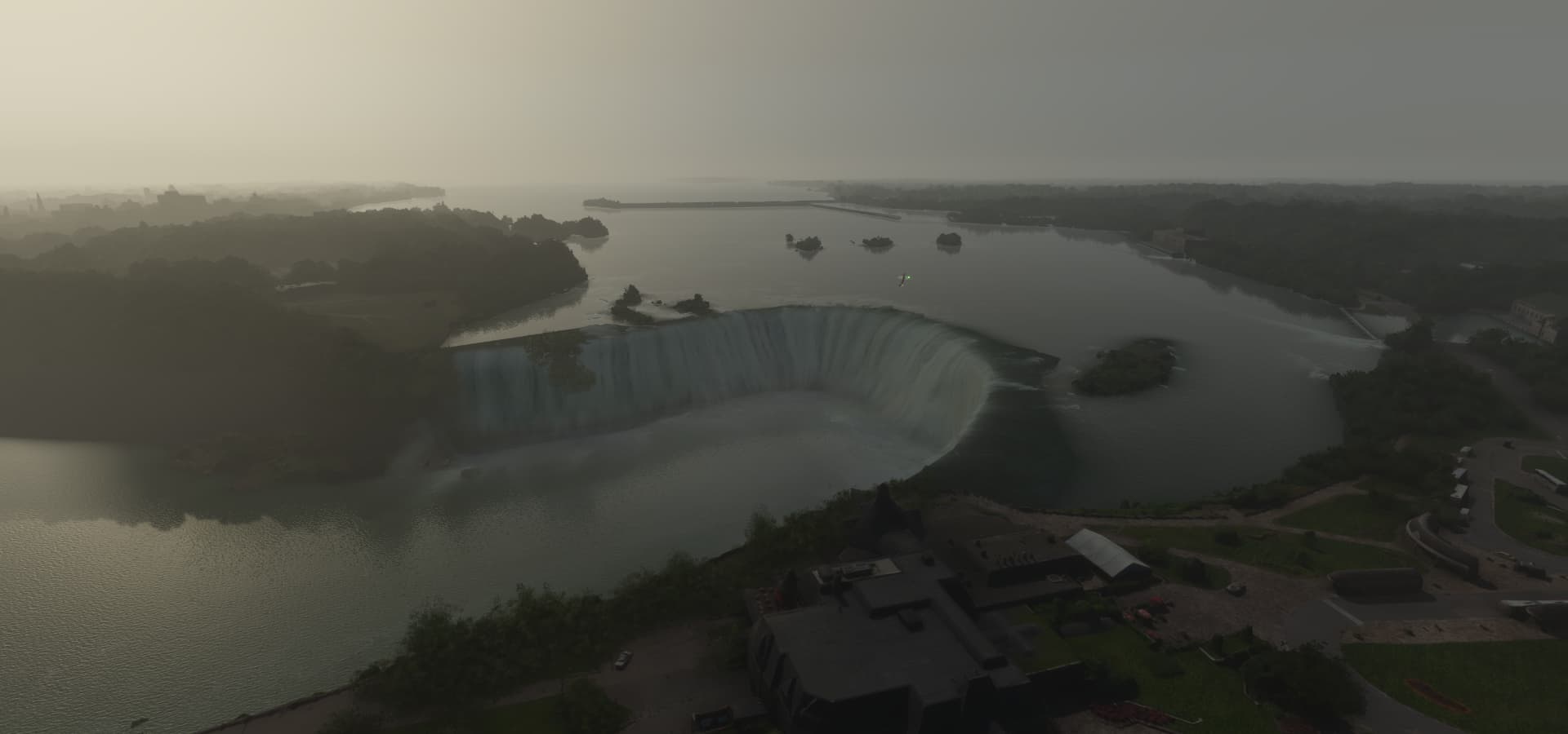
Anyone want to see what Canada looked like in 2020 / 2021, look for the legs in Canada here
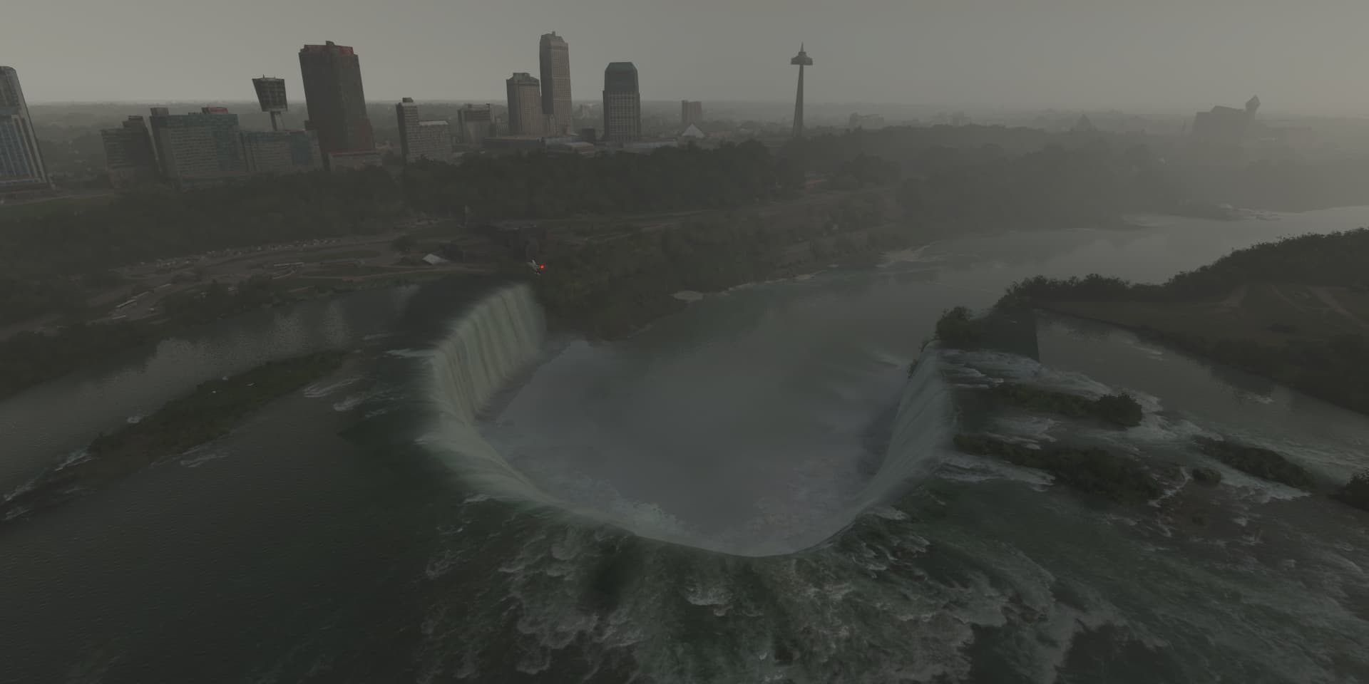
This is what Niagara falls looked like in 2021, weather wasn’t cooperating
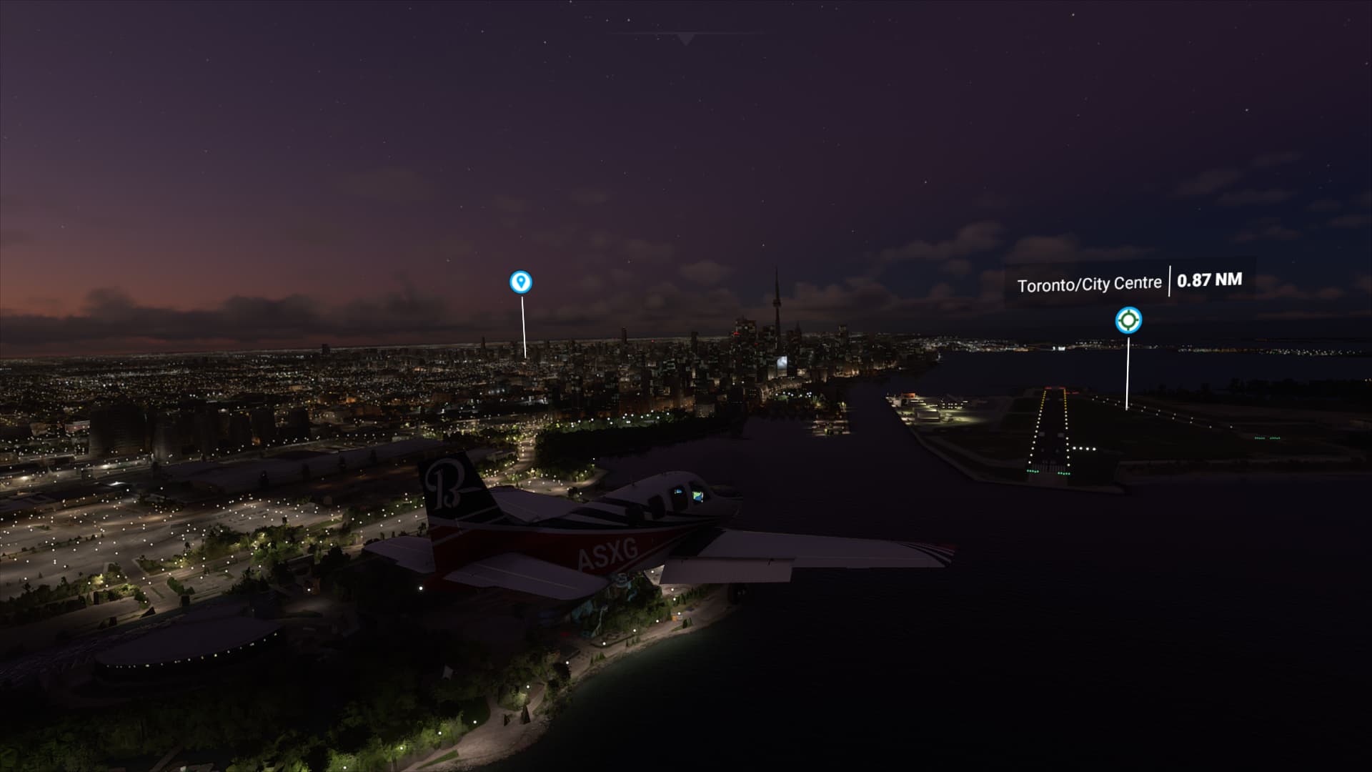
And Toronto in 2020, it was dark already when I got there
So was looking forward to make a Canada specific tour but will wait.
I was mostly hoping for better coverage up North, the national parks in particular, Labrador where Alone: Frozen was filmed. But it seems Bing maps hasn’t improved much if at all for Northern Canada. Alert CYLT and Grise Fiord CYGZ looked horrible with the scenery in between giant pixels. (Still no CYGZ in FS2020) And still trees in Alert ![]()
2 Likes
But the pools are frozen in the winter. This explains why the Quebec hockey players can skate circles around other hockey players. ![]()
1 Like
Hello everyone,
please stay on topic.
Thank you.
2 Likes

Montreal photogrammetry following the Canada Update. Some have complained about scenery errors in and around the city but, unless I fly within a hundred metres of a given building, it never melts. The trees are too tall and too numerous, of course; the cathedral shows only its green dome here while in real life, the church rises entirely above the surrounding trees. Place Bonaventure really has trees on its roof, as depicted here, but said trees are far fewer in number on the ground around that building. But, I’m being too picky here, I can’t really complain. I fervently wish the devs are able to do as good a job with the rest of Canada as was achieved in Montreal, and the sooner the better.
4 Likes
Can’t say the same. Even the logos at the top of buildings somehow look worse, it’s surprising.
But the saddest part is that big issues like missing buildings between the runways at YUL (montreal airport) are still totally missing… like the headquarters of Bombardier. It’s a tower, but it’s flat on the Sim: Google Maps