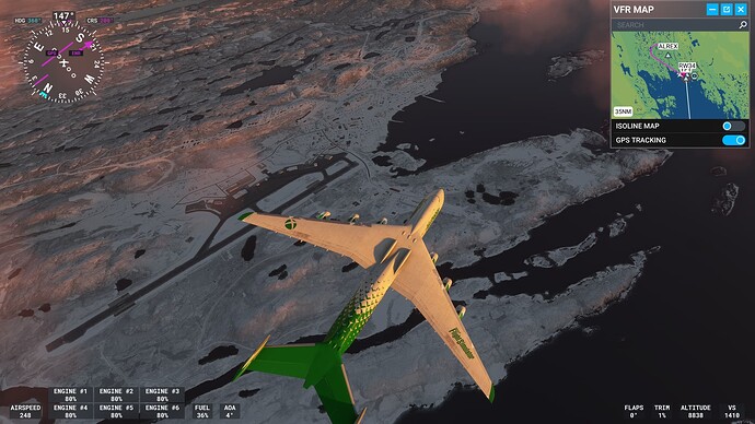
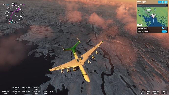
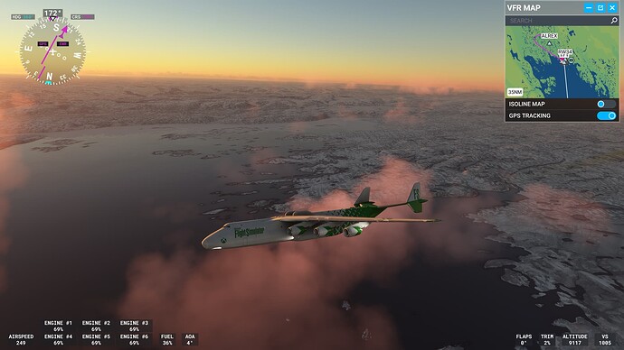
Still, frozen ocean in Norway. Please fix…!
I totally agree. This would be an easy workaround until a more realistic system is in place. I‘d much rather have no frozen water at all than this, and if I were to fly in the arctic region I could still turn it on.
No snow accumulation on the ground at Montreal today, which does not correspond to the actual current condition. Not even with +SN specified on the METAR and present snowfall being showed on the simulator.
I’m wondering if it might not be easier to just abandon water body ice all together. It happens so rarely outside of the poles, and when it does appear in the sim, it’s almost always wrong / unrealistic.
We often bring it up, but again I get to Milford Sound in 15ºC ground temperatures to find the inlet frozen. Just daft, and missed sales for the devs who made such a good package which I won’t be buying until I can enjoy visiting it, and MS’ marketplace sales.
The snow I can understand being worth our patience while it’s tweaked (even at this glacial (sic) pace), but the sea ice? It’s almost always just wrong.
Lakes freeze over but I agree for the most part we’d be better off without the sea ice outside of the (ant)artic circles.
Unfortunately SU 14 has not solved the snow and ice issue as promised at all. E. g. here in the Innsbruck (LOWI) area where I live in real live all the valleys are currently green only the mountain tops are covered with snow. In MSFS though the whole region is covered with a thick layer of snow and even the rivers are frozen, which never ever happens in real live.
We had this wrong depiction in MSFS already during the whole last winter season which forced me to avoid flying around in my native area and it sadly seems, that it will be the same during this winter season again. ![]()
I feel you! But at least you’re seeing snow in Winter time. I checked out the new Milford Sound scenery in New Zealand yesterday and turned on real weather. It was completely snowed in and frozen all over! It’s Summer there. Asobo, please!
I understand what you mean. But since global warming also we haver very, very rarely a snow cover down in the valleys these days and the landscape is usually green. Even after the very rare event of a snofall the cover usually lasts only for a few hours and the landscape is never looking like Antarctica like it does in MSFS.
BTW last season the thick snow and ice cover in MSFS stayed until March/April in my home area, when real life temperatures had already been risen above 20° Celsius. So I think you can expect a Southern summer full of snow in the Milford Sound area. ![]()
Take care!
I thought global warming leads to a sudden freezing event.
In any case, frozen lakes and rivers should depend on temperature, high altitudes and certain latitudes. Now a counter example from me.
I was in Iqaluit on the Arctic Ocean two days ago. It was -29°C on the ground and the temperatures had been in the double-digit minus range for weeks. So all the lakes there must definitely be frozen over.
Since this engine is very strongly influenced by high mountains and the landscape there is rather flat, the lakes there do not freeze over because there apparently is not enough snow and there are no high mountains.
This is a perfect example of what data the engine is missing.
Solution approach:
-Eliminate dependence on high mountains for rivers and lakes, up to a certain altitude, e.g. up to 2000m above sea level
-Create dependence on latitude in interaction with local temperatures (no historical temperature necessary).
-Otherwise, if the above factors are not present, do not let the lakes and rivers freeze!
-Create a button in the settings with which you can toggle the freezing of rivers and lakes in the live weather, in case a larger lake in Switzerland were to freeze by half in reality.
Then we have more ice in the northern latitudes, as in reality and, for example, in Central Europe or on the fjords in Norway little ice or manually adjustable in the live weather. Otherwise, for example from 2000m above sea level in the Alps etc. icing as usual (weather permitting)
Then it is very easy for Seb (Asobo) to implement and makes everyone happy.
Cheers
Still terrible snow coverage in central Switzerland (and many other parts of the world) - Is it that hard to make snow altitude dependent? We have snowy mountains but today it’s 10+ degrees in the valleys, only had snow like one day in the valleys this winter, yet in the sim everything is completely white. Even parts of lake Lucerne and lake Sarnen are completely frozen in the sim. In 25 years I’ve lived here lake Sarnen has never been frozen.
Flew to Denver from Boise and no snow on the ground. Some mountain peaks had snow but that’s it. Loaded in Winnipeg Canada and no snow on the ground there either. Not correct there is snow on the ground there IRL. Hopefully this can be resolved soon
This. For sure there are other factors affecting snow retention such as slope aspect etc, but by far the most important is altitude and if they just fix that one it’ll probably get us 90% of the way there.
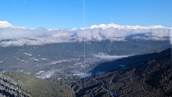
This is what the real world looks like:
Until they build altitude into the simulation then no matter how much they try to improve the resolution of snow forecasts, it is never going to be able to simulate this properly. Instead in the sim we get peak to valley snow on a mountain right next to peak to valley greenfields and a vertical line separating them! It couldn’t look more unrealistic.
I don’t think this ever will be fixed as the data itself is extremely buggy. From a programming perspective this would be an incredibly difficult problem to solve. For several reasons. 1. the source data is not detailed enough. 2. the source data is old or incorrect most of the time. 3. I’m not sure how they would make it elevation dependent given that almost everything in FS is a grid base on geographic location. How would the sim know an elevation without millions of data points? Even that would cause problems because you would have to define the area where the snow levels are and Let’s say the snow level is 2500ft near Bellingham WA but it’s 4000 feet near Olympia, WA, how do you transition. Even more problematic is that snow levels fluctuate throughout a day. 4. The source data has huge gaps, look at Meteoblue’s snow depth data, and it’s laughable.
There is only one solution to this problem: better, sharper more complete snow depth data from Meteoblue being put into the sim. but good luck with that, its a very difficult thing to determine.
Honestly I think Asobo has bitten off more than they can chew given the poor quality of Meteoblue snow depth data and it will just be a constant source of irritation for players because it sounds great in theory but is difficult to transfer to the sim itself.
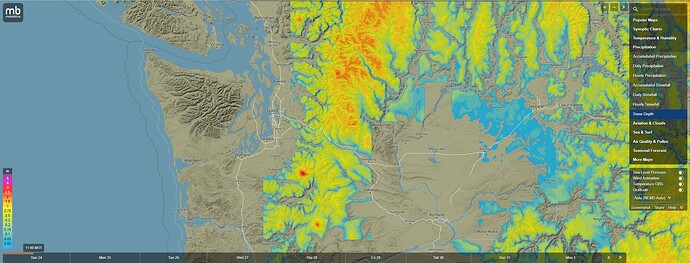
Here is a good example of how bad the data is. Notice that the Olympics of Washington have zero snow according to meteo
blue data. No snow on the mountains of Vancouver Island, places where the snow coverage just cuts off in a line. So point is if you have bad data or the data isn’t fine enough you’re always going to have this problem.
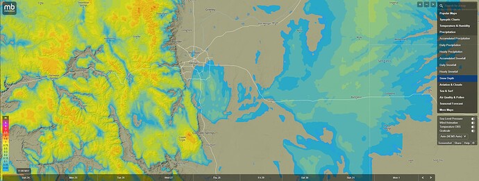
Another example that shows why elevation won’t work. There is snow in the Colorado mountains, but there is also snow on the Colorado plains east of Denver so how would you determine how to place that snow if it were below a certain level? You can’t use freezing level either because it’s freezing at ground level.
Even if you can determine that, you still have the problem of snow showers/timing of the freezing level. In the US/Canada, you could have 3 feet snow in a narrow band 20 miles wide in the great lakes, In the intermountain west I have seen a narrow band of snow dump a foot on Denver then 50 miles north they never saw a snowflake.
That’s exactly what the DEM is. The sim already uses elevation maps for the whole world, without that it wouldn’t be able to render the planet in 3D at all.
As to the data, forecast models already have freezing level data, it’s pretty standard, all Asobo need to do is join the freezing level to the DEM when rendering.
Would this make the snow correct? No, I agree with you on one thing only, and that is it’ll probably never be able to get correct snow representation because the number of factors is huge and very localised effects can be significant.
I’d be very happy if the snow looked realistic and roughly matched the right areas. The meteoblue data should let them get roughly the correct areas to draw snow, and then the freezing level data can modify this to look realistic.
I’m not sure about rest-of-world, but the US National Operational Hydrologic Remote Sensing Center (NOHRSC) has a ton of snow data, all geocoded and updated very often. Unfortunately, I don’t think those data can be integrated into a one-stop shop for the entire world.
Freezing level is not really a good indicator of snowpack. You can have several inches to feet of snow at temperatures well above freezing and it is dependent on too many other factors to make that the determinant. It just needs more granular gridded data.
Yes for sure. Freezing level is only applicable at the point the snow falls. It certainly would not be good if the snow receded up the mountain during the day and advanced back down as the temperature dropped in the evening. Therefore using live freezing level is not the answer and it’s definitely more complicated than that, but it is the freezing level that determines the altitude lines as in the picture I posted, and this is crucial to build into the model to make it look realistic.
This is a reminder that this thread is meant to serve as a bug topic, not a discussion topic. If you are experiencing this issue and have not already reported, please feel free to report your findings using the following template. In addition, if you find workarounds or processes that helped resolve the bug for you, please feel free to post about it, as it may help the team’s investigation. Outside of this, please use an existing or new topic in the appropriate Discussion Hub to discuss this bug. All other posts will be removed.
![]() For anyone who wants to contribute on this issue, Click on the button below to use this template:
For anyone who wants to contribute on this issue, Click on the button below to use this template:
Do you have the same issue if you follow the OP’s steps to reproduce it?
Provide extra information to complete the original description of the issue:
If relevant, provide additional screenshots/video:
Do you have the same issue if you follow the OP’s steps to reproduce it?
Yes
Provide extra information to complete the original description of the issue:
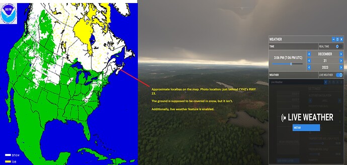
As of today, December 31, 2023, there is a significant amount of snow in Nova Scotia, Canada. For reference, I checked both meteoblue.com’s snow cover map and NOAA’s snow cover map (https://usicecenter.gov/products/ims/ims_v3/ims_gif/ARCHIVE/USA/2023/ims2023364_usa.gif). According to both maps, there is snow cover in the area of CYHZ. However, even with the live weather feature enabled in MSFS, I do not observe any snow.
If relevant, provide additional screenshots/video:
I’ve merged two photos into one for comparison. On the left, you’ll find the continental US snow and ice coverage map (retrieved from https://usicecenter.gov/products/ims/ims_v3/ims_gif/ARCHIVE/USA/2023/ims2023364_usa.gif), and on the right, MSFS.
As shown in the photo below, the entire province of Nova Scotia is currently covered in snow due to overnight and early morning snowfall. The map has been updated to reflect this. Additionally, I’ve noticed that meteoblue’s map has also been updated to show the snow coverage today. However, when I look at MSFS, I see the opposite – no snow in this area.
I look forward to this issue being fixed ASAP!
Thanks!
