I know that many people like to just fire up the Sim and take off to see the simulated world, but perhaps, there is small fraction of people that like to take the simulation to the limit. In order to do that, there is a need to do a few things before you take off. Some of the things that a pilot needs to do are a weather briefing, getting to know the route of your flight, calculate aircraft weights, balance, fuel requirements and flight times. For those of you that might be interested, follow along, I will show you how I do it and contrary to what you think, this process does not add more than 15min to your flight, and will give you total control and knowledge of the aircraft, the route, and the weather around you.
This whole planning thing is - within the limitations of the game - similar to what is done in flight schools around the world.
To give you some context, I am doing an around the world tour, and the idea is to fly with real weather, mostly VFR, low (below 7500’ unless is needed for obstacle clearance), and slow (I am using the C172). Because I want it to be VFR, just like IRL, I won’t be able to fly every day, at any time, I will have to find the right conditions to fly. Right now, I am stationed on the east US part of my world tour, stationed at KJAX in northern FL, USA and the route will take me north around the east coast, so I can cross The Atlantic towards Europe.
Today we will be talking about weather forecasting and planning.
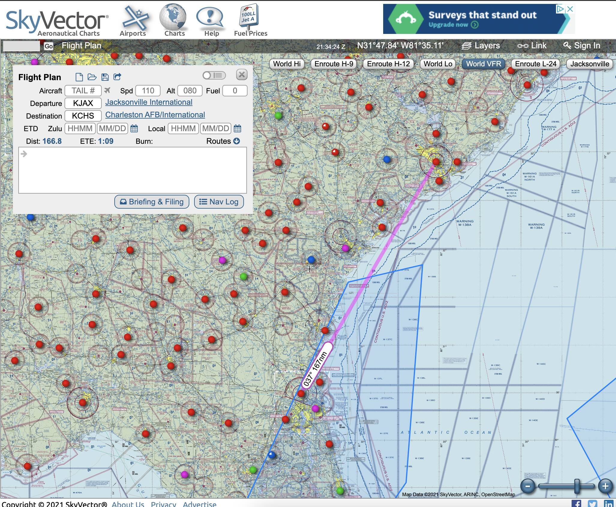
The first step is to go to www.skyvector.com and create a route. You can put as many waypoints as you want, but the overall idea here is to have a basic idea on where your fight is going through, so just starting with the departing and arrival airports is fine. The usual lengths of my flights are below 2 hrs so I am usually between 160 and 200 nm. We will have a chance to plan a more detailed route later.
In the map, my first two waypoints for this flight will be KJAX to KCHS (167 nm):
The next step is to figure out when I can fly. I will need close to ideal conditions, at a minimum marginal VFR (1000-3000′ and/or 3-5 miles). Although if needed, I could fly IFR, but the idea is to go mostly VFR. (I include an IFR plan and I am prepared to fly IFR if the conditions are not ideal, but with this planning, 95% of the time I can complete my flights VFR)
The main problem with MSFS 2020 is that the weather is a complex approximation of real life conditions, is not really an exact mirror of what is happening in the real world. After researching, there is nobody, as of now, that has been able to extract or see the weather code inside the sim, but we actually know the weather source for MSF: MeteoBlue, it seems that this is where the info that is fed into the weather engine of MSFS is coming from.
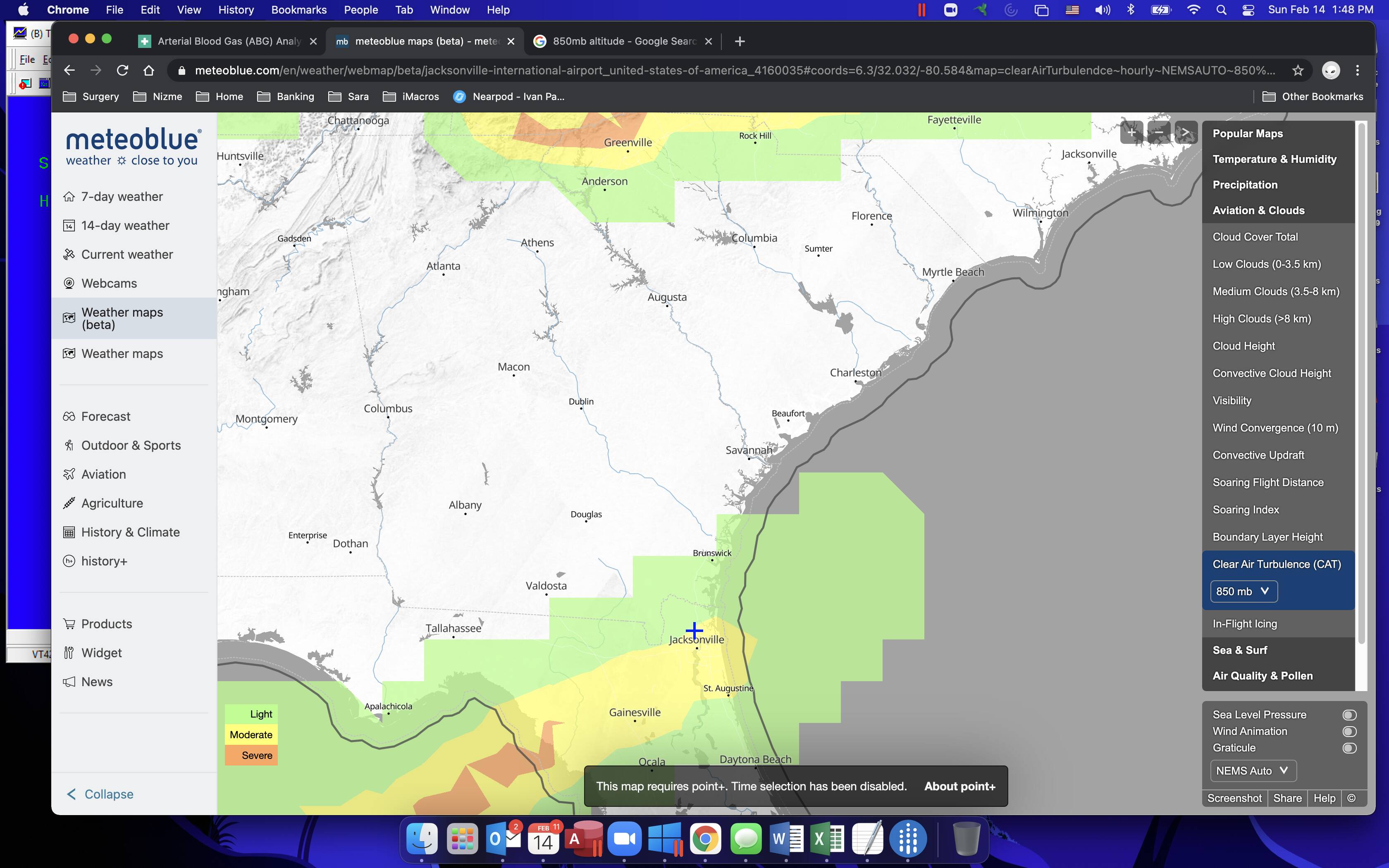
So… go to www.meteoblue.com and search for the departing airport by ICAO, in this case KJAX. Click on the left column on “weather maps (beta)” and on the right “Aviation & Clouds” and zoom out to include the arrival.
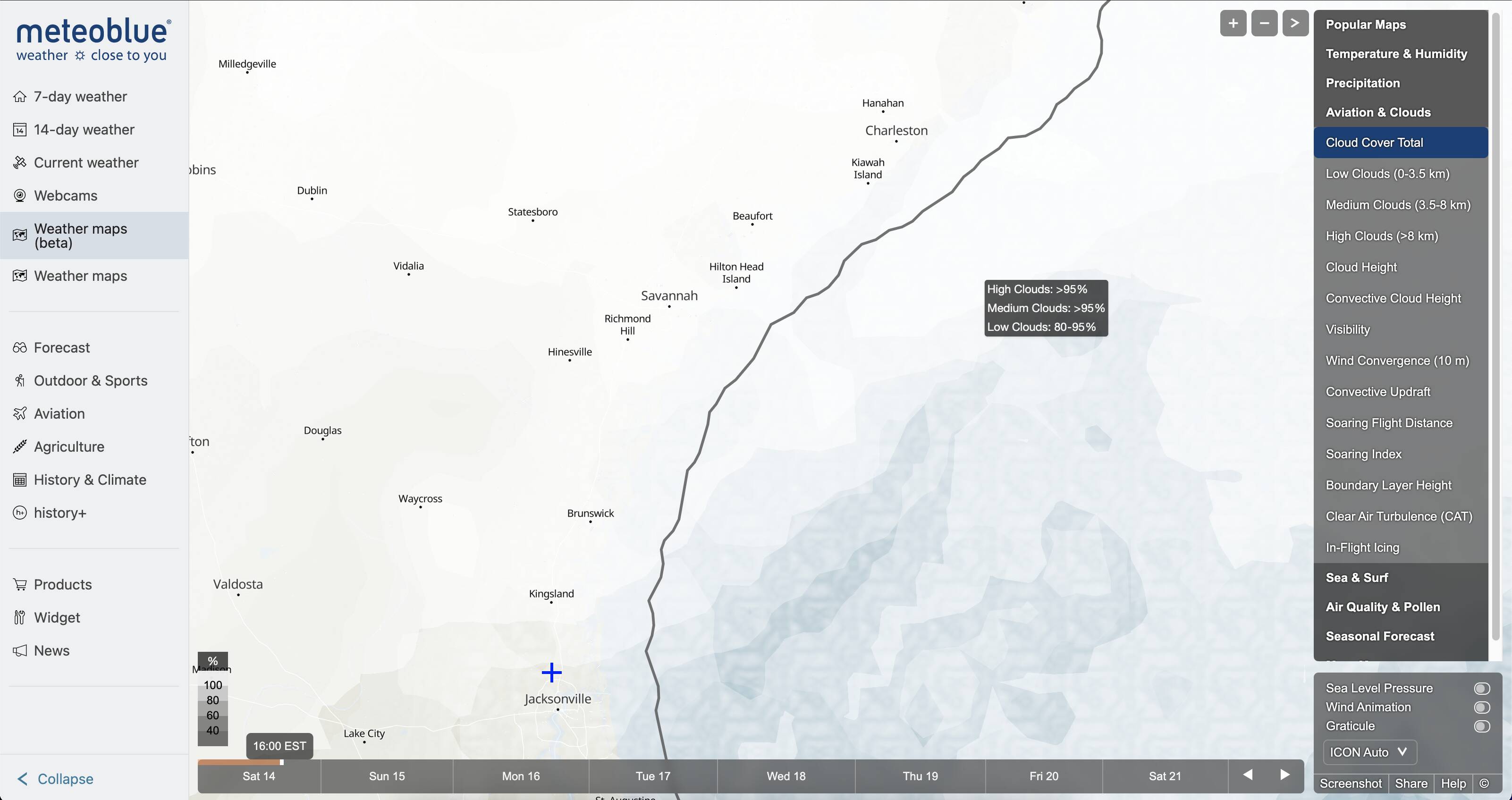
As you can see on the pictures, on Saturday, there was heavy non VFR conditions with almost complete coverage of low and high clouds and by Tuesday in the morning, the clouds would dissipate and almost my entire route will be without much cloud cover. - which is indicative of a low pressure front (bad for aviation) moving south east as the days pass by:

After seeing that, I knew that by Tuesday in the AM, I would be able to do this flight on VFR with real live weather. But this is just the beginning, continue reading for more…
On the right hand side, you can click on the different options for weather, for us low and slow flyers, the “low cloud coverage” is critical, and the system is metric. So for reference, 3.5Km is about 11,500 feet, which is close to the practical ceiling of my C172. But If there is cloud coverage, I would also look at the “high cloud coverage”, sometimes these are massive gigantic cumulonimbus formations (Storm clouds) that sometimes reach up to 40,000 ft or more and everyone should avoid.
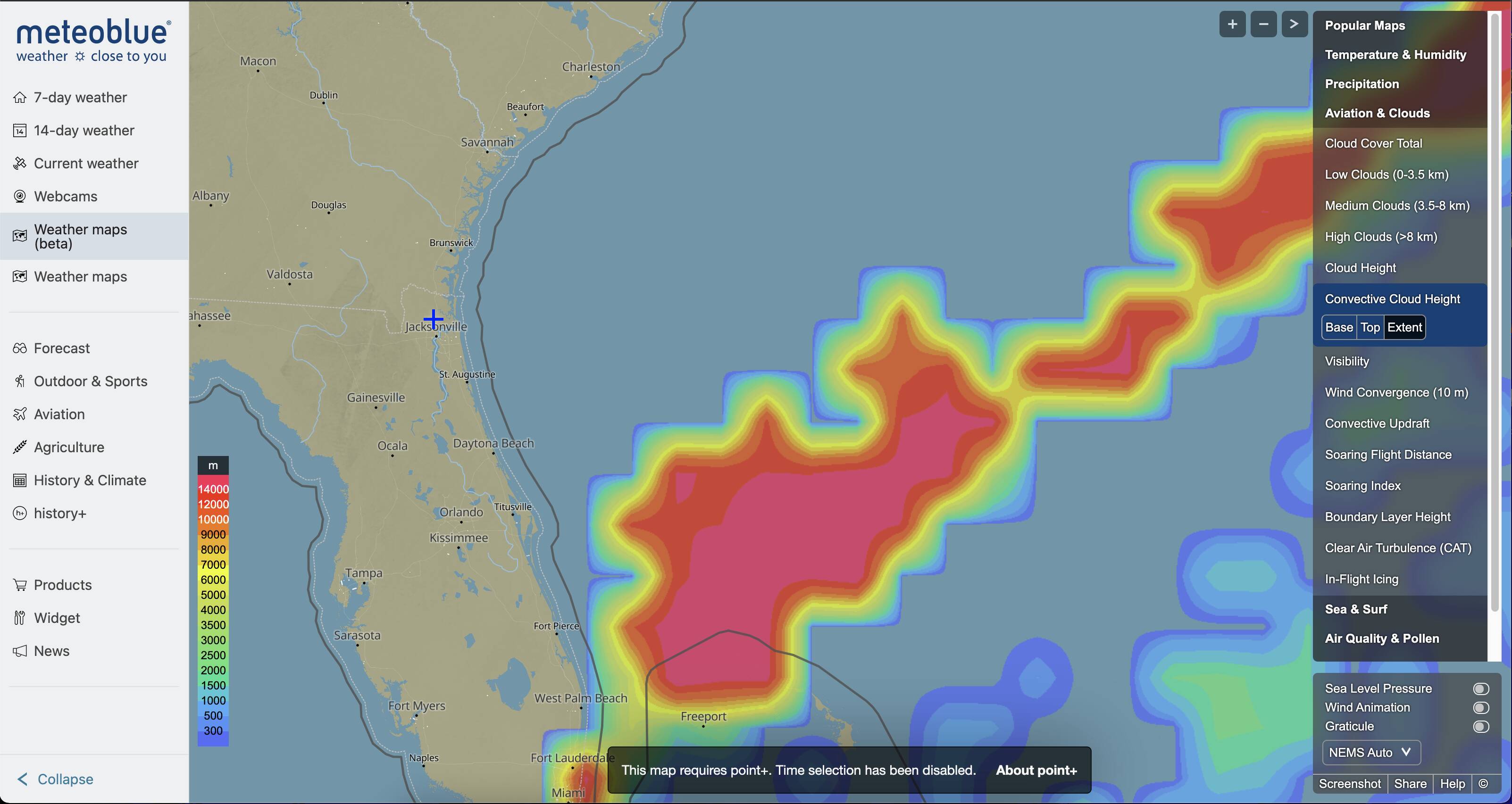
These formations can be seen on the “Convective cloud height” map (above), again, you should not fly close under or through these formations, and even the heavy flyers avoid them.
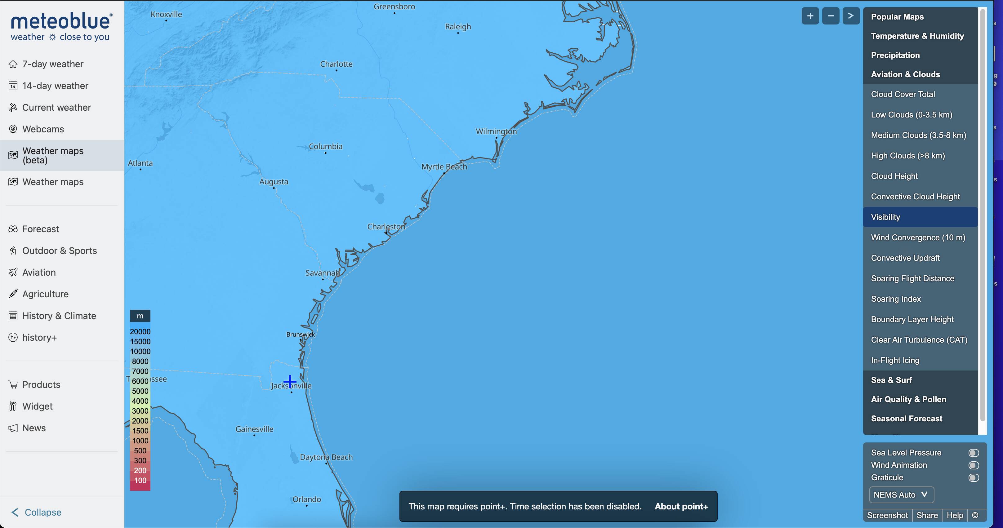
The next option is “visibility”. For VFR and to be able to do some good old dead reckoning, you will need good visibility. See the difference between Saturday, and Tuesday (my planned day of the trip)
The next options, Convective updraft, Soaring Flight distance, Soaring index will be handy when gliders are modeled by MSFS. I see great potential here, not only for those who like that genre, but also to improve the flight modeling and include those forces. But I think that as of now (Mid February of 2021, is not modeled).
The other map that I need to see is “CAT (Clear air turbulence)” I need to take my passengers with comfort. Note, Altitude here is referred in terms of pressure (mb) So is necessary to google a conversion chart., In this case, 850mb in standard conditions is equivalent to 4700 feet. Kinda the altitude that I want to fly through. In my case, there will be some expected light turbulence on take off, climb and the first part of my cruise but I should expect a Smooth flight from there on:
Those of you wondering how to find Icing, you can click on the the next option “in-flight icing” for the same altitude, you can see that there is no expected Icing during my fight, which otherwise would ground me as the C172 is not certified to fly in known Icing Conditions.
And that finishes the Basic Weather Forecasting of the flight. In conclusion with the forecasted conditions, I would be able to fly from KJAX to KCHS, VFR anywhere at 3500, 5500 or 7500 feet (the proper altitude for the direction of my flight, according to the FAA) with minimal cloud coverage, no convective activity or precipitation, good visibility, light turbulence only at the beginning of the flight and no icing risk on Tuesday at 8:00 AM.
Throughout the rest of the weekend, while I enjoy Valentine’s Day with the family, I will log on on the website once daily and see if the forecasted conditions have changed.
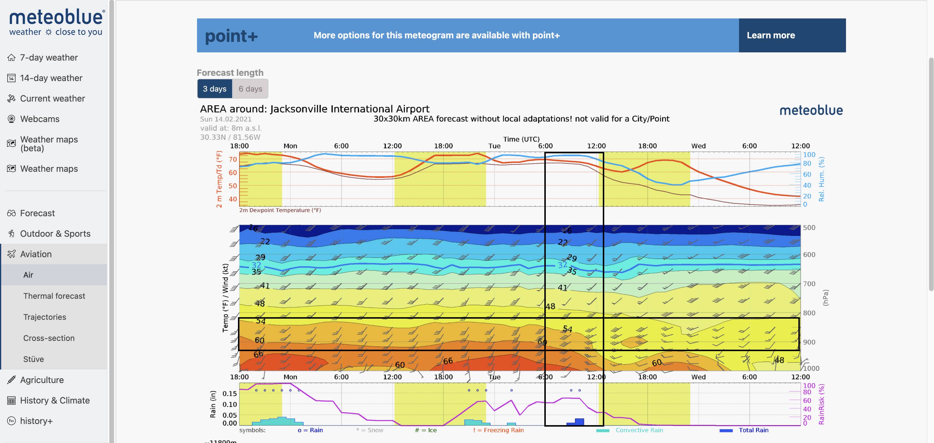
On the night before the flight I will do a final check and will include an Expanded Weather Briefing that will include temperatures, winds aloft, humidity and dew point on a few spots around the route.
In order to get this information, I will click on the left on “Aviation - Air”. The picture below shows KJAX, the vertical square shows the date and time of my flight and the horizontal square my cruise altitude, the forecast shows that I will have temperatures in the low 70s, very narrow dew-point (high moisture in the air) and close to 100% relative humidity, which in turn means that there might be some fog, but that the density altitude will not be that high and my aircraft performance will not be affected much (this is specially important when taking off from high altitude fields at or near maximum takeoff weight):
I will repeat this check for my destination airport.
En-route, is good to know the winds aloft, and how fast I will be moving over the ground, sometimes, this check helps me plan a better, much more efficient altitude to save some fuel and time. On the same graphic you can see the intersection of the two squares, where the traditional barb wind graphic shows that the winds will be coming from the SW (almost a tail wind - great) and that they will be 20 to 40 knots as I climb, and that the OAT will be in the lower 50s F. This winds aloft check I repeat it on a couple of places on the route, (in my particular case, Brunswick and Savanah)
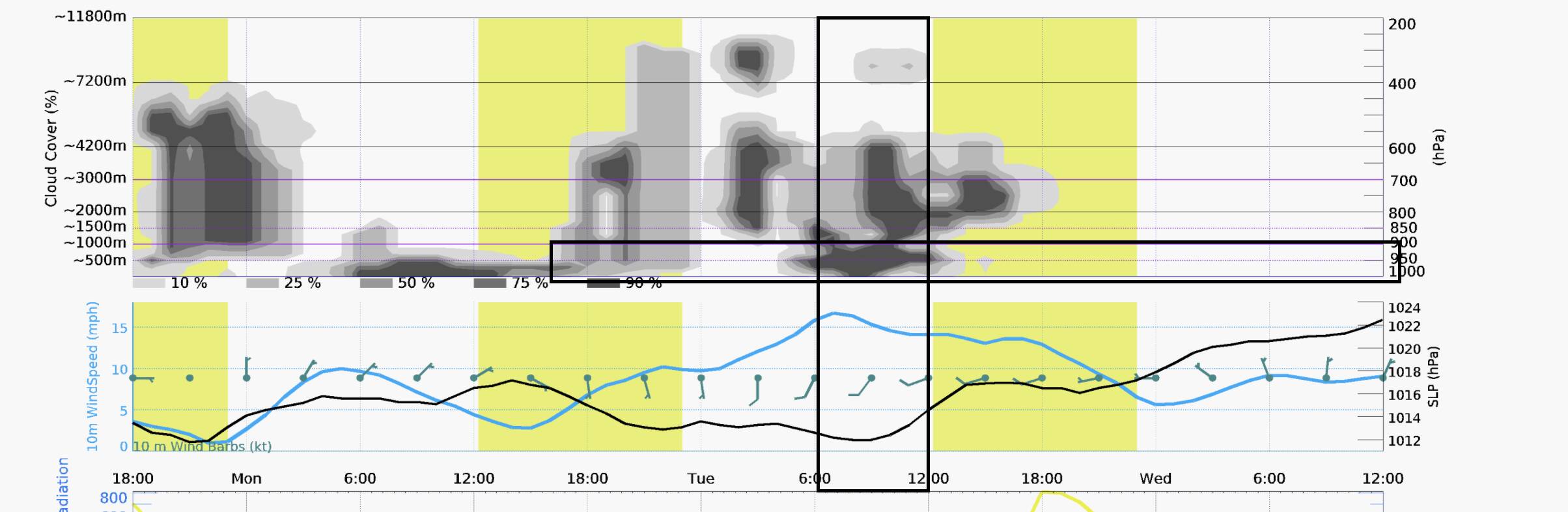
Finally, I check, for the origin and the destination airport, cloud coverage and surface winds. The graph at the bottom (Below) depicts also the timeframe of my fight and the altitude. Here we can see that there will be somewhat heavy cloud coverage on top of my departure and that the surface winds will be about 10 knots from the SW and the W.
That concludes the weather briefing for my flight. It sounds terribly long, but it can be done in just 5 min. I use a piece of paper and write down the information.
Crosschecking with MSFS, this is the closest to the weather seen in the simulator. Not even the ATIS of the local airport comes close and is so accurate that it allows me to do proper flight planning, kind in the way is done in real life.
More posts on these series:
- Weather forecasting Here
- Planning the VFR route Here
- Preflight Checks Here
- How everything comes together Here
All these are critical components of Dead Reckoning, and pilotage, so we can ditch the GPS and fly this just by looking outside and comparing the references on the map to the planned route. Its really cool and makes for a fun flight on a VFR simulation platform, just like MSFS.
Because my preferred way of playing is via VR, I need to move my headset every now and then to see the map, but hopefully some sort of VR browser will be included in the sim in the next updates.
Weather forecasting and a weather briefing is a key part of flight planning and flying and we can do it all in the sim. It makes for a better experience for those like me, that love the fine detail. That’s all for now, let me know if you have corrections, or additions. I will be happy to answer any questions.