Sure, that was my second point actually. Satalite imagery is different on different “zoom” levels. With zoom in respect to the sim, how close you are on the ground. Satalites take images from earth with different zoom levels so to speak (I try to simplify it, otherwise look at the end of this post with a link to bing maps tile system which also has other interesting menu links).
Example when i was flying over the saltiplano salt planes in bolivia. This is at image coordinates
-20,138332, -67,162336
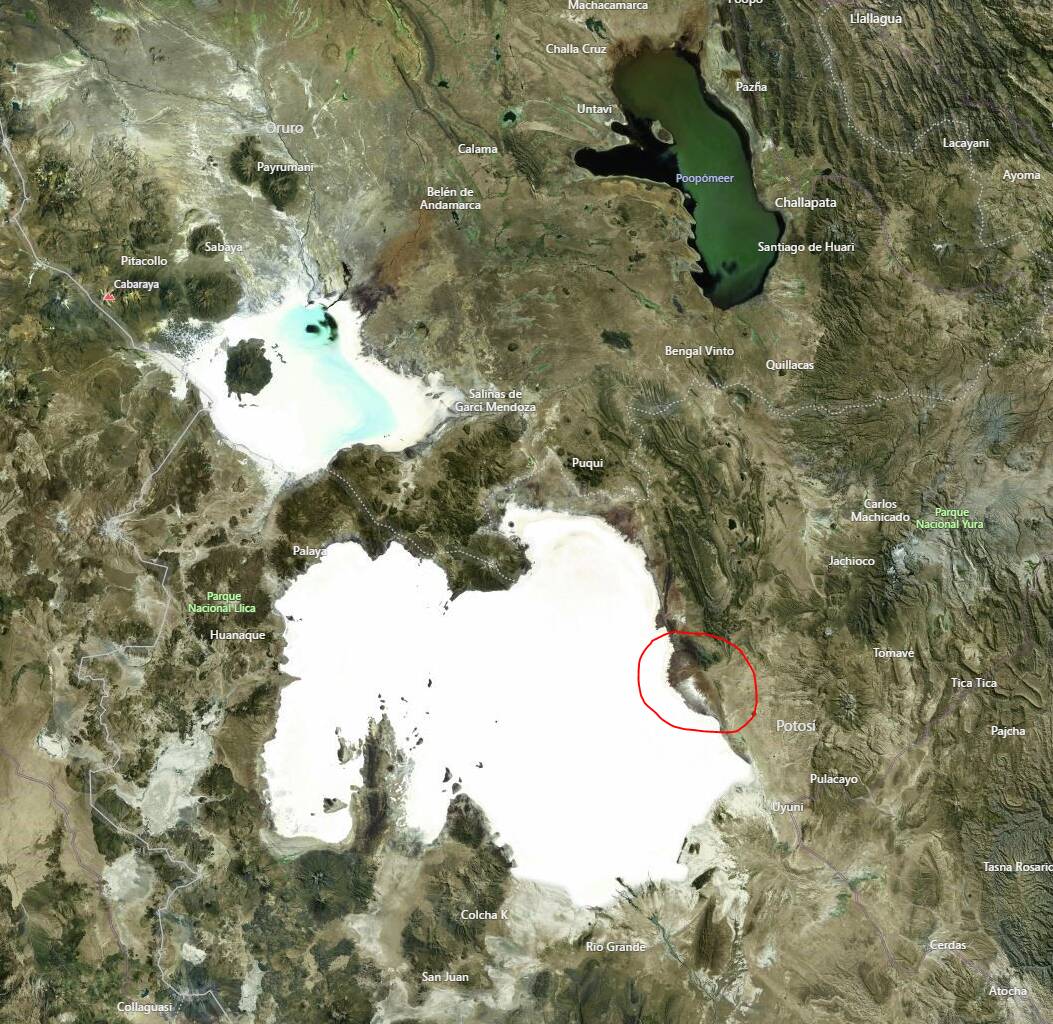
I will zoom in at the red circle to try to make my point why the tiling is so ■■■■ obvious sometimes.
This is the image when zoomed in, it’s exactly the same image, but more crisp as i’m closer to it. This definitely looks like a textures which was used when i was quite far from the salt plane

I’m clearly able to recognize this because i was flying over that specific spot. But watch this,
We are getting really close, we are flying almost over that coordinate (couple miles out maybe?)
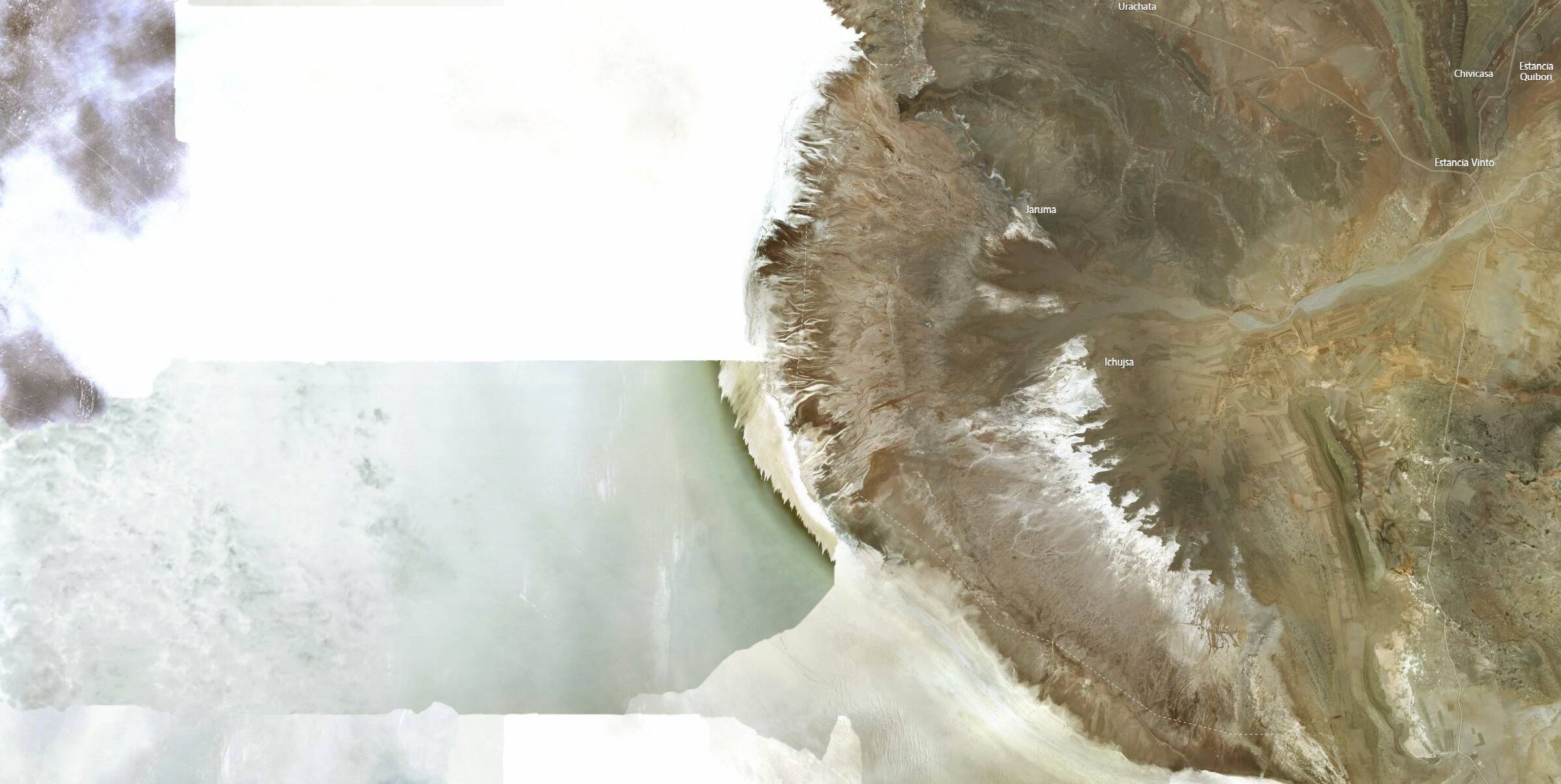
This is the exact same location, only one step closer zoomed in. You can see clearly the squared tile, these are individual images, taken at different times.
I explicitely choose the saltiplano in this example is able to show it in an extreme case.
- The top left tile is overexposed under looks like heavy cloud cover. (it’s a salt plane, a tiny layer of water could do that).
- The middle up square: There is no higher resolution “zoomed” in satalite image,
- Look at the bottom, looks like a different month(year?)
- etc… etc…
It’s a mess. And as with the sim. Garbage in, Garbage out. There is just so much AI can do. And this image is just about 500 square mile? 1969007 square miles to go (give or take). Let’s check them all shall we? but, times two at minimal if i’m corect, because the imagery used are different layers. Maybe three, not sure.
So, what i’m trying to say here is that at a big distance, you do not need that much detail. When coming close, you do. When the high altitude imagery (when you are far away), is at a different moment then the low altitude (sun light/winter period/extreme heavy cloudy (search venezuela on bing maps zoom levels, different cloud coverage on different heights, when flying there you see this, the coverage is so much it can’t be “fixed” by the AI trying to equal, zoom in/out on El Lechozo
9,293852, -66,683722
) you will see a massive difference. It also does not make sense to have high resolution high detail textures at far. You won’t be able to make up the details anyway. And because low resolution and high resolution satalite pictures are often taken at different day/night/week/seasons, there are places where you really notice this.
But, why is it tiled? Well, satellite images are tiled, and also is quite common.
Asobo is simulating viewing distance (like so many apps do) so lower resolution images in a distance is logical, as also with your eyes you can’t see the same details as when up close.
So, why do you see blurry ground textures when zooming in? In fact you are looking with binoculars. Unfortunately, at textures which are “far away” (like also many other apps). This where possibly the slider comes in or maybe two or three sliders. Texture and Objects, maybe also foilage, if i’m correct i have seen something about that on the whish list.
So as a response to the couple of connection/bandwith remarks:
Your or MS’s bandwith or server load is not the only reason: SU5, terrible GFX - #69 by scriptkid
Also, do not forget router memory exhaustion, Teredo issues, etc… My router has that exhaustion issue, causing all kind of connection bs (tcp drops, connection drops, etc…), especially when when everyone is doing something wired and wireless (combined 2.5 and 5Ghz). One of my issues have been someone in the family broadcast bombing my network.
But, also to be fair, i have seen dips in the MS network which often starts at those big boy border routers (for real time data). Next to that, textures seem to fetched from Akamai and/or Amazon aws. These are the guys which redirects users to “proper” servers providing best quality based on your/connection peers locations. Anyone correct me if i’m wrong here, but it appears that way.
Correct, they are purposed and dedicated in regards to gaming (although they can do much more, netflix etc). But because there have been optimizations for xbox which runs on windows (simplified here) with directx, pc users also benefit. Or better said are benefitting to much?
There have been a lot of complaints about memory usage, needing a beefy machine. So people choose to spend a s**load of money to get these. As did I, because i want the best of the best and do not settle for less (I lied, I refuse to choose for scalper and extreme inflation prices).
So, they have done rendering optimizations and please read @CptLucky8’s post on object detail (notice the similarities between far and close?)
But, I don’t believe the pc version has not been altered to fit xbox. It has been altered to our whishes, because, if you really want, you would be able to get it, maybe not as much as you would like. But, i was reading something about sliders? ![]() :
:
- [CONT] Official Discussion: Hotfix 1.18.15.0 - #239 by scriptkid
- [CONT] Official Discussion: Hotfix 1.18.15.0 - #242 by TwoSuitz
Bonus:
Bing maps tile system: Bing Maps Tile System - Bing Maps | Microsoft Learn
And again, nope. Not giving up on simming after V. In fact, started tinkering with electronics again after update V.
My two cents, cheers!
Edit: Corrected some bing maps links